
Olympic Peninsula topographic map
Interactive map
Click on the map to display elevation.
About this map
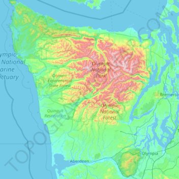
Name: Olympic Peninsula topographic map, elevation, terrain.
Location: Olympic Peninsula, Washington, United States (46.81549 -124.73338 48.39177 -122.61009)
Average elevation: 229 m
Minimum elevation: -3 m
Maximum elevation: 2,279 m
The Olympic Peninsula is a large arm of land in western Washington that lies across Puget Sound from Seattle, and contains Olympic National Park. It is bounded on the west by the Pacific Ocean, the north by the Strait of Juan de Fuca, and the east by Hood Canal. Cape Alava, the westernmost point in the contiguous United States, and Cape Flattery, the northwesternmost point, are on the peninsula. Comprising about 3,600 square miles (9,300 km2), the Olympic Peninsula contained many of the last unexplored places in the contiguous United States. It remained largely unmapped until Arthur Dodwell and Theodore Rixon mapped most of its topography and timber resources between 1898 and 1900.
Other topographic maps
Click on a map to view its topography, its elevation and its terrain.
Seattle
United States > Washington > King County
Seattle, King County, Washington, United States
Average elevation: 40 m
Whidbey Island
United States > Washington > Island County
Whidbey Island, Island County, Washington, United States
Average elevation: 45 m
San Juan Island
United States > Washington > San Juan County > Friday Harbor
San Juan Island, Friday Harbor, San Juan County, Washington, 98250, United States
Average elevation: 26 m
Port Orchard
United States > Washington > Kitsap County
Port Orchard, Kitsap County, Washington, United States
Average elevation: 71 m
Spokane
United States > Washington > Spokane County
Spokane, Spokane County, Washington, United States
Average elevation: 655 m
Bellingham
United States > Washington > Whatcom County
Bellingham, Whatcom County, Washington, United States
Average elevation: 89 m
Renton
United States > Washington > King County
Renton, King County, Washington, United States
Average elevation: 83 m
Ocean Shores
United States > Washington > Grays Harbor County
Ocean Shores, Grays Harbor County, Washington, 98569, United States
Average elevation: 1 m
Bainbridge Island
United States > Washington > Kitsap County
Bainbridge Island, Kitsap County, Washington, 98110, United States
Average elevation: 24 m
Kennewick
United States > Washington > Benton County
Kennewick, Benton County, Washington, United States
Average elevation: 154 m
Orcas Island
United States > Washington > San Juan County > Eastsound
Orcas Island, Eastsound, San Juan County, Washington, United States
Average elevation: 59 m
Olympia
United States > Washington > Thurston County
Olympia, Thurston County, Washington, United States
Average elevation: 49 m
Walla Walla
United States > Washington > Walla Walla County
Walla Walla, Walla Walla County, Washington, 99362, United States
Average elevation: 297 m
Lewis County
Lewis County, Washington, United States
Average elevation: 580 m
Edmonds
United States > Washington > Snohomish County
Edmonds, Snohomish County, Washington, United States
Average elevation: 44 m
Redmond
United States > Washington > King County
Redmond, King County, Washington, United States
Average elevation: 72 m
Mount Vernon
United States > Washington > Skagit County
Mount Vernon, Skagit County, Washington, 98273, United States
Average elevation: 37 m
Chelan County
Chelan County, Washington, United States
Average elevation: 1,094 m
Oak Harbor
United States > Washington > Island County
Oak Harbor, Island County, Washington, United States
Average elevation: 31 m
Federal Way
United States > Washington > King County
Federal Way, King County, Washington, United States
Average elevation: 81 m
Bonney Lake
United States > Washington > Pierce County
Bonney Lake, Pierce County, Washington, United States
Average elevation: 152 m
Port Angeles
United States > Washington > Clallam County
Port Angeles, Clallam County, Washington, 98362, United States
Average elevation: 27 m
Arlington
United States > Washington > Snohomish County
Arlington, Snohomish County, Washington, United States
Average elevation: 60 m
Vashon Island
United States > Washington > King County > Vashon
Vashon Island, Vashon, King County, Washington, 98070, United States
Average elevation: 46 m
Marysville
United States > Washington > Snohomish County
Marysville, Snohomish County, Washington, United States
Average elevation: 72 m
Mount Rainier National Park
United States > Washington > Pierce County
Mount Rainier National Park, Pierce County, Washington, United States
Average elevation: 1,412 m
Kirkland
United States > Washington > King County
Kirkland, King County, Washington, United States
Average elevation: 58 m
Island County
Island County, Washington, United States
Average elevation: 98 m
Snohomish County
Snohomish County, Washington, United States
Average elevation: 649 m
Lopez Island
United States > Washington > San Juan County > Lopez Village
Lopez Island, Lopez Village, San Juan County, Washington, 98261, United States
Average elevation: 21 m
Anacortes
United States > Washington > Skagit County
Anacortes, Skagit County, Washington, 98221, United States
Average elevation: 36 m
Pullman
United States > Washington > Whitman County
Pullman, Whitman County, Washington, United States
Average elevation: 774 m
Fidalgo Island
United States > Washington > Skagit County > Anacortes
Fidalgo Island, Anacortes, Skagit County, Washington, United States
Average elevation: 32 m
Cowlitz County
Cowlitz County, Washington, United States
Average elevation: 359 m
Gig Harbor
United States > Washington > Pierce County
Gig Harbor, Pierce County, Washington, 98335, United States
Average elevation: 49 m
Sammamish
United States > Washington > King County
Sammamish, King County, Washington, United States
Average elevation: 97 m
Vancouver
United States > Washington > Clark County
Vancouver, Clark County, Washington, United States
Average elevation: 54 m
Moses Lake
United States > Washington > Grant County
Moses Lake, Grant County, Washington, 98837, United States
Average elevation: 350 m
Kittitas County
Kittitas County, Washington, United States
Average elevation: 924 m
Wenatchee
United States > Washington > Chelan County
Wenatchee, Chelan County, Washington, 98801, United States
Average elevation: 302 m
Auburn
United States > Washington > King County
Auburn, King County, Washington, United States
Average elevation: 88 m
Tacoma
United States > Washington > Pierce County
Tacoma, Pierce County, Washington, United States
Average elevation: 67 m
Leavenworth
United States > Washington > Chelan County
Leavenworth, Chelan County, Washington, United States
Average elevation: 418 m
Mud Lake
United States > Washington > Okanogan County
Mud Lake, Okanogan County, Washington, United States
Average elevation: 813 m
Issaquah
United States > Washington > King County
Issaquah, King County, Washington, United States
Average elevation: 164 m
Monroe
United States > Washington > Snohomish County
Monroe, Snohomish County, Washington, 98272, United States
Average elevation: 49 m
Spokane County
Spokane County, Washington, United States
Average elevation: 741 m
North Bend
United States > Washington > King County
North Bend, King County, Washington, United States
Average elevation: 160 m
Longview
United States > Washington > Cowlitz County
Longview, Cowlitz County, Washington, United States
Average elevation: 50 m