
Snohomish County topographic map
Interactive map
Click on the map to display elevation.
About this map
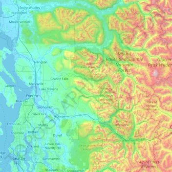
Name: Snohomish County topographic map, elevation, terrain.
Location: Snohomish County, Washington, United States (47.77548 -122.44257 48.29923 -120.90674)
Average elevation: 649 m
Minimum elevation: -4 m
Maximum elevation: 3,186 m
The lowland areas of western Snohomish County generally has a temperate Mediterranean climate similar to the rest of the central Puget Sound region with dry summers and wet winters. The county's weather is heavily influenced by maritime systems, pushed by prevailing westerly winds but dampened by the Olympic Mountains. The mean monthly temperatures for the county range from 20 to 40 °F (−7 to 4 °C) during the winter and 55 to 65 °F (13 to 18 °C) in the summer. The record highest temperatures were set during a June 2021 heat wave, with highs of up to 109 °F (43 °C) recorded in several areas. Annual precipitation ranges from 35 inches (89 cm) in the west to 180 inches (460 cm) in the upper elevations of the Cascades; the majority of the region's precipitation falls between October and March. The county's lowlands also has an average annual snowfall ranging from 10 to 20 inches (25 to 51 cm). The Puget Sound Convergence Zone, a known meteorological phenomenon, runs through southwestern Snohomish County and causes narrow bands of precipitation.
Other topographic maps
Click on a map to view its topography, its elevation and its terrain.
Spokane
United States > Washington > Spokane County
Spokane, Spokane County, Washington, United States
Average elevation: 655 m
Camano Island
United States > Washington > Island County
Camano Island, Island County, Washington, 98282, United States
Average elevation: 27 m
Whatcom County
Whatcom County, Washington, United States
Average elevation: 753 m
Puget Sound
United States > Washington > Edmonds
Puget Sound, Admiral Way, Edmonds, Snohomish County, Washington, 98020, United States
Average elevation: 0 m
Seattle
United States > Washington > King County
Seattle, King County, Washington, United States
Average elevation: 40 m
Bremerton
United States > Washington > Kitsap County
Bremerton, Kitsap County, Washington, United States
Average elevation: 68 m
Clark County
Clark County, Washington, United States
Average elevation: 266 m
Pierce County
Pierce County, Washington, United States
Average elevation: 498 m
Kitsap County
Kitsap County, Washington, United States
Average elevation: 138 m
Olympic National Park
Olympic National Park, Washington, United States
Average elevation: 412 m
Kent
United States > Washington > King County
Kent, King County, Washington, United States
Average elevation: 87 m
Lake Stevens
United States > Washington > Snohomish County > Lake Stevens
Lake Stevens, Snohomish County, Washington, United States
Average elevation: 82 m
Poulsbo
United States > Washington > Kitsap County
Poulsbo, Kitsap County, Washington, United States
Average elevation: 75 m
Sequim
United States > Washington > Clallam County
Sequim, Clallam County, Washington, United States
Average elevation: 88 m
Yakima County
Yakima County, Washington, United States
Average elevation: 879 m
Camas
United States > Washington > Clark County
Camas, Clark County, Washington, 98607, United States
Average elevation: 94 m
Spokane Valley
United States > Washington > Spokane County
Spokane Valley, Spokane County, Washington, United States
Average elevation: 673 m
Shoreline
United States > Washington > King County
Shoreline, King County, Washington, 98155, United States
Average elevation: 99 m
Clallam County
Clallam County, Washington, United States
Average elevation: 335 m
Index
United States > Washington > Snohomish County
Index, Snohomish County, Washington, United States
Average elevation: 366 m
Queen Anne Hill
United States > Washington > King County > Seattle
Queen Anne Hill, Seattle, King County, Washington, 98109, United States
Average elevation: 55 m
Normandy Park
United States > Washington > King County
Normandy Park, King County, Washington, United States
Average elevation: 57 m
Port Townsend
United States > Washington > Indian Island
Port Townsend, Jefferson County, Washington, 98368, United States
Average elevation: 0 m
Thurston County
Thurston County, Washington, United States
Average elevation: 150 m
Touchet
United States > Washington > Walla Walla County > Touchet
Touchet, Walla Walla County, Washington, 99360, United States
Average elevation: 139 m
Woodinville
United States > Washington > King County
Woodinville, King County, Washington, United States
Average elevation: 73 m
Snoqualmie Pass
United States > Washington > Kittitas County
Snoqualmie Pass, Kittitas County, Washington, United States
Average elevation: 955 m
Winthrop
United States > Washington > Okanogan County
Winthrop, Okanogan County, Washington, 98862, United States
Average elevation: 567 m
Richland
United States > Washington > Benton County
Richland, Benton County, Washington, United States
Average elevation: 160 m
Maple Valley
United States > Washington > King County
Maple Valley, King County, Washington, 98038, United States
Average elevation: 160 m
Ceres
United States > Washington > Lewis County
Ceres, Lewis County, Washington, United States
Average elevation: 123 m
Grays Harbor County
Grays Harbor County, Washington, United States
Average elevation: 171 m
Mount Si
United States > Washington > King County
Mount Si, King County, Washington, 98045, United States
Average elevation: 787 m
Hanford
United States > Washington > Benton County
Hanford, Benton County, Washington, United States
Average elevation: 123 m
Silverdale
United States > Washington > Kitsap County
Silverdale, Kitsap County, Washington, 98383, United States
Average elevation: 68 m
Easton
United States > Washington > Kittitas County
Easton, Kittitas County, Washington, 98925, United States
Average elevation: 742 m
Long Beach
United States > Washington > Pacific County
Long Beach, Pacific County, Washington, 98631, United States
Average elevation: 3 m
Paramount Park
United States > Washington > King County > Shoreline
Paramount Park, Shoreline, King County, Washington, 98155, United States
Average elevation: 110 m
Lummi Island
United States > Washington > Whatcom County
Lummi Island, Whatcom County, Washington, United States
Average elevation: 24 m
Gifford Pinchot National Forest
United States > Washington > Skamania County
Gifford Pinchot National Forest, Skamania County, Washington, United States
Average elevation: 769 m
Mercer Island
United States > Washington > King County
Mercer Island, King County, Washington, 98040, United States
Average elevation: 38 m
Weallup Lake
United States > Washington > Snohomish County
Weallup Lake, Snohomish County, Washington, United States
Average elevation: 112 m
Grotto
United States > Washington > King County
Grotto, King County, Washington, 98224, United States
Average elevation: 528 m
Vesta
United States > Washington > Grays Harbor County
Vesta, Grays Harbor County, Washington, United States
Average elevation: 86 m
Clinton Park
United States > Washington > Pierce County > Lakewood
Clinton Park, Lakewood, Pierce County, Washington, 98498, United States
Average elevation: 77 m
Rochester
United States > Washington > Thurston County
Rochester, Thurston County, Washington, United States
Average elevation: 42 m
Duvall
United States > Washington > King County
Duvall, King County, Washington, United States
Average elevation: 50 m
Northport
United States > Washington > Stevens County
Northport, Stevens County, Washington, 99157, United States
Average elevation: 500 m