
Olympic National Park topographic map
Interactive map
Click on the map to display elevation.
Olympic National Park
Views of the Olympic National Park can be seen from the Hurricane Ridge viewpoint. The road leading west from the Hurricane Ridge visitor center has several picnic areas and trailheads. A paved trail called the Hurricane Hill trail is about 1.6 miles (2.6 km) long each way, with an elevation gain of about 700 feet (210 m). It is not uncommon to find snow on the trails even as late as July. Several other dirt trails of varying distances and difficulty levels branch off of the Hurricane hill trail. The picnic areas are open only in the summer and have restrooms, water, and paved access to picnic tables.
About this map
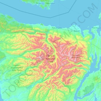
Name: Olympic National Park topographic map, elevation, terrain.
Location: Olympic National Park, Washington, United States (47.46977 -124.74259 48.27526 -123.12402)
Average elevation: 412 m
Minimum elevation: -3 m
Maximum elevation: 2,367 m
Other topographic maps
Click on a map to view its topography, its elevation and its terrain.
Spokane
United States > Washington > Spokane County
Spokane is located on the Spokane River in eastern Washington at an elevation of 1,843 feet (562 m) above sea level, about 18 miles (29 km) from Idaho, 92 miles (148 km) south of the Canadian border, 229 miles (369 km) due east of Seattle, and 279 miles (449 km) southwest of Calgary. The lowest elevation in…
Average elevation: 655 m
Seattle
United States > Washington > King County
The city itself is hilly, though not uniformly so. Like Rome, the city is said to lie on seven hills; the lists vary but typically include Capitol Hill, First Hill, West Seattle, Beacon Hill, Queen Anne, Magnolia, and the former Denny Hill. The Wallingford, Delridge, Mount Baker, Seward Park, Washington Park,…
Average elevation: 40 m
Clark County
Many lakes border the river in the lowlands near Ridgefield, including Vancouver Lake. Eastern and northern Clark County contain forested foothills of the Cascade Mountains, rising to an elevation of 4,000 feet (1,200 m) on the border with Skamania County. Larch Mountain is the county's highest free-standing…
Average elevation: 266 m
Richland
United States > Washington > Benton County
According to the United States Census Bureau, the city has a total area of 39.11 square miles (101.29 km2), of which, 35.72 square miles (92.51 km2) is land and 3.39 square miles (8.78 km2) is water. Elevation at the airport is 120 m (390 ft).
Average elevation: 164 m
Black Peak
United States > Washington > Skagit County
Black Peak is a tall peak in the Cascade Range in the U.S. state of Washington. It lies in the Stephen Mather Wilderness and North Cascades National Park. At 8,975 feet (2,736 m) in elevation it is the 20th-highest peak in Washington. Black Peaks's prominence is 3,450 feet (1,050 m), making it the 35th-most…
Average elevation: 2,098 m
Mount Redoubt
United States > Washington > Whatcom County
The North Cascades features some of the most rugged topography in the Cascade Range with craggy peaks, spires, ridges, and deep glacial valleys. Geological events occurring many years ago created the diverse topography and drastic elevation changes over the Cascade Range leading to the various climate…
Average elevation: 2,070 m
Moses Coulee
United States > Washington > Douglas County
Pleistocene glaciers advanced onto the Waterville Plateau, with the Okanogan Lobe of the Cordilleran Ice Sheet reaching as far south as the town of Withrow. Evidence for glaciation on the Waterville Plateau includes polished and striated bedrock, glacial erratics, drumlinoid topography, eskers, moraines,…
Average elevation: 666 m
Whidbey Island
United States > Washington > Island County
Whidbey Island lies partially in the rain shadow of the Olympic Mountain Range to the west, and has a variety of climate zones. This can be observed by rainfall amounts – wettest in the south with average rainfall of 36 inches (910 mm), driest in the central district of Coupeville with average rainfall of 20…
Average elevation: 45 m
Copalis Beach
United States > Washington > Grays Harbor County > Copalis Beach
Average elevation: 13 m
Pullman
United States > Washington > Whitman County
The city is situated across several loess hills which characterize the Palouse Prairie, formed from windblown sediment over an estimated period of over one million years. This prairie region, the Palouse, is noteworthy for its fertile rolling hills where winter and spring wheat, barley, canola, lentils, and…
Average elevation: 774 m
Snohomish County
The lowland areas of western Snohomish County generally has a temperate Mediterranean climate similar to the rest of the central Puget Sound region with dry summers and wet winters. The county's weather is heavily influenced by maritime systems, pushed by prevailing westerly winds but dampened by the Olympic…
Average elevation: 649 m
Glacier Peak
United States > Washington > Snohomish County
Despite its elevation of 10,541 feet (3,213 m), Glacier Peak is a small stratovolcano. Its relatively high summit is a consequence of its location atop a high ridge, but its volcanic portion extends only 1,600–3,200 feet (500–1,000 m) above the underlying ridge. Another Cascade Arc volcano with similar…
Average elevation: 2,656 m
Fort Townsend Historical State Park
United States > Washington > Jefferson County
Average elevation: 57 m
Liberty Lake
United States > Washington > Spokane County
Areas east of Liberty Lake Road and areas north of Appleway Road lie on the relatively flat land along the floor of the Spokane Valley. Elevations there range from between 2,000 feet above sea level at the river to around 2,150 feet around Liberty Lake Elementary School. The areas west of Liberty Lake Road and…
Average elevation: 644 m
Mount Rainier
United States > Washington > Pierce County
Mount Rainier (/reɪˈnɪər/ ray-NEER), also known as Tahoma, is a large active stratovolcano in the Cascade Range of the Pacific Northwest in the United States. The mountain is located in Mount Rainier National Park about 59 miles (95 km) south-southeast of Seattle. With a summit elevation of 14,411 ft…
Average elevation: 3,912 m
Aberdeen
United States > Washington > Grays Harbor County
Aberdeen is at the eastern end of Grays Harbor, near the mouth of the Chehalis River and southwest of the Olympic Mountains. Grays Harbor is notable as the northernmost ria on North America's Pacific Coast because it has remained free of glaciers throughout the Quaternary due to unfavorable topography and warm…
Average elevation: 48 m
Ephrata
United States > Washington > Grant County
The settlement of Ephrata is quite recent. There was no known settlement until 1886, just three years before Washington gained statehood. The horse rancher Frank Beezley was the first to settle near the natural springs, thus the area was known as Beezley Springs. As the climate and topography were not…
Average elevation: 434 m
Longview
United States > Washington > Cowlitz County
Longview is located in a small gorge, so its climate varies from that of its close neighbor, Portland. Longview is generally about 7 °F (4 °C) cooler than Portland. Located about 80 miles (130 km) inland across a stretch of relatively flat ground, the Longview skies can be overcast due to moisture from the…
Average elevation: 50 m
Ford
United States > Washington > Stevens County
Ford is located in a mountainous area at the base of Happy Hill, which rises more than 600 feet immediately to the southeast of the community. The northeast–southwest trending Walkers Prairie and valley floor along which Chamokane Creek flows is relatively flat and at an elevation of between 1,700 and 1,800…
Average elevation: 577 m
Stanwood
United States > Washington > Snohomish County
The city is located at the mouth of the Stillaguamish River, where it flows into Port Susan, an arm of the Puget Sound, and Skagit Bay, the mouth of the Skagit River. To the west is Davis Slough, which separates Stanwood from Camano Island and forms the border between Snohomish and Island counties. Elevations…
Average elevation: 20 m