
Crofton topographic map
Interactive map
Click on the map to display elevation.
About this map
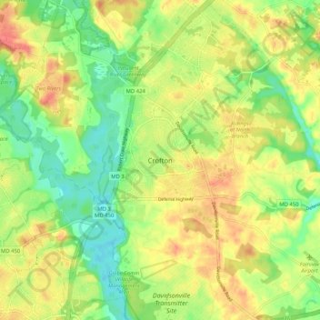
Name: Crofton topographic map, elevation, terrain.
Location: Crofton, Anne Arundel County, Maryland, 21114, United States (38.96178 -76.72747 39.04178 -76.64747)
Average elevation: 35 m
Minimum elevation: 4 m
Maximum elevation: 68 m
Other topographic maps
Click on a map to view its topography, its elevation and its terrain.
Annapolis
United States > Maryland > Anne Arundel County
Annapolis, Anne Arundel County, Maryland, United States
Average elevation: 8 m
Little John
United States > Maryland > Anne Arundel County
Little John, Anne Arundel County, Maryland, 21405, United States
Average elevation: 16 m
Gambrills
United States > Maryland > Anne Arundel County > Gambrills
Gambrills, Anne Arundel County, Maryland, United States
Average elevation: 37 m
Severn
United States > Maryland > Anne Arundel County > Severn
Severn, Anne Arundel County, Maryland, United States
Average elevation: 47 m
Nottingham
United States > Maryland > Anne Arundel County
Nottingham, Anne Arundel County, Maryland, 21405, United States
Average elevation: 16 m
Severna Park
United States > Maryland > Anne Arundel County
Severna Park, Anne Arundel County, Maryland, 21146, United States
Average elevation: 14 m
Millersville
United States > Maryland > Anne Arundel County
Millersville, Anne Arundel County, Maryland, 21054, United States
Average elevation: 38 m
Arnold
United States > Maryland > Anne Arundel County
Arnold, Anne Arundel County, Maryland, 21012, United States
Average elevation: 15 m
Riva
United States > Maryland > Anne Arundel County
Riva, Anne Arundel County, Maryland, 21041, United States
Average elevation: 11 m
Pasadena
United States > Maryland > Anne Arundel County
Pasadena, Anne Arundel County, Maryland, 21122, United States
Average elevation: 16 m
Sturbridge
United States > Maryland > Anne Arundel County > Arnold
Sturbridge, Arnold, Anne Arundel County, Maryland, 22409, United States
Average elevation: 21 m
Glen Burnie
United States > Maryland > Anne Arundel County
Glen Burnie, Anne Arundel County, Maryland, 21061, United States
Average elevation: 25 m
Severn
United States > Maryland > Anne Arundel County
Severn, Anne Arundel County, Maryland, 21144, United States
Average elevation: 43 m
Davidsonville
United States > Maryland > Anne Arundel County
Davidsonville, Anne Arundel County, Maryland, 21035, United States
Average elevation: 37 m
North Welham
United States > Maryland > Anne Arundel County > Ferndale
North Welham, Ferndale, Anne Arundel County, Maryland, 21062, United States
Average elevation: 25 m
Crownsville
United States > Maryland > Anne Arundel County > Crownsville
Crownsville, Anne Arundel County, Maryland, 21140, United States
Average elevation: 30 m
Patapsco River
United States > Maryland > Anne Arundel County > Riviera Beach
Patapsco River, Riviera Beach, Anne Arundel County, Maryland, United States
Average elevation: 7 m
Kitty Creek
United States > Maryland > Anne Arundel County > Annapolis Neck
Kitty Creek, Annapolis Neck, Anne Arundel County, Maryland, 21403, United States
Average elevation: 6 m
Linthicum
United States > Maryland > Anne Arundel County
Linthicum, Anne Arundel County, Maryland, 21090, United States
Average elevation: 32 m
Cape St. Claire
United States > Maryland > Anne Arundel County > Cape Saint Claire
Cape St. Claire, Cape Saint Claire, Anne Arundel County, Maryland, United States
Average elevation: 12 m
Severna Park
United States > Maryland > Anne Arundel County > Severna Park
Severna Park, Anne Arundel County, Maryland, United States
Average elevation: 20 m
Clumber
United States > Maryland > Anne Arundel County > Clumber
Clumber, Anne Arundel County, Maryland, 21405, United States
Average elevation: 17 m
Orchard Beach
United States > Maryland > Anne Arundel County > Riviera Beach > Orchard Beach
Orchard Beach, Riviera Beach, Anne Arundel County, Maryland, 21122, United States
Average elevation: 6 m
Maryland City
United States > Maryland > Anne Arundel County > Maryland City
Maryland City, Anne Arundel County, Maryland, United States
Average elevation: 53 m
Shoreham Beach
United States > Maryland > Anne Arundel County > Shoreham Beach
Shoreham Beach, Anne Arundel County, Maryland, 21037, United States
Average elevation: 2 m
Odenton
United States > Maryland > Anne Arundel County
Odenton, Anne Arundel County, Maryland, 21112, United States
Average elevation: 49 m
Crofton
United States > Maryland > Anne Arundel County > Crofton
Crofton, Anne Arundel County, Maryland, 21114, United States
Average elevation: 35 m