
Ticino topographic map
Interactive map
Click on the map to display elevation.
About this map
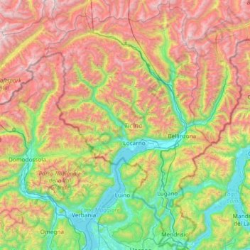
Name: Ticino topographic map, elevation, terrain.
Location: Ticino, Switzerland (45.81797 8.38204 46.63249 9.15970)
Average elevation: 1,389 m
Minimum elevation: 187 m
Maximum elevation: 3,546 m
Although it includes the lowest point of Switzerland (Lake Maggiore) as well as its lowest town (Ascona), the topography of Ticino is extremely rugged, as it is the fourth canton with the biggest elevation difference. It lies essentially within the Alps, in particular the Lepontine Alps, the Saint-Gotthard Massif and the Lugano Prealps. The longest and deepest valleys are those of the Ticino, Verzasca and Maggia. The two highest mountains are the Rheinwaldhorn and the Basòdino. Other notable mountains are Pizzo Rotondo (highest of the Gotthard Massif), Pizzo Campo Tencia (highest fully within the canton), Monte Generoso (highest south of Lake Lugano) and Monte Tamaro (most prominent of the canton). For an exhaustive list, see list of mountains of Ticino.
Other topographic maps
Click on a map to view its topography, its elevation and its terrain.
Zurich
Switzerland > Zurich > District Zurich
Zurich, District Zurich, Zurich, Switzerland
Average elevation: 499 m
Ötlisberg
Switzerland > Zurich > District Zurich > Zurich
Ötlisberg, Zurich, District Zurich, Zurich, 8125, Switzerland
Average elevation: 626 m
Bern
Switzerland > Bern > Bern-Mittelland administrative district
Bern, Bern-Mittelland administrative district, Bernese Mittelland administrative region, Bern, Switzerland
Average elevation: 612 m
Uetliberg
Switzerland > Zurich > Bezirk Affoltern > Stallikon
Uetliberg, Stallikon, Bezirk Affoltern, Zurich, 8143, Switzerland
Average elevation: 624 m
Zermatt
Switzerland > Wallis > Visp
Zermatt, Visp, Wallis, 3920, Switzerland
Average elevation: 2,921 m
Matterhorn
Switzerland > Wallis > Visp > Zermatt
Matterhorn, Zermatt, Visp, Wallis, 3920, Switzerland
Average elevation: 3,295 m
Ussers Läger
Switzerland > Bern > Interlaken-Oberhasli administrative district > Oberried am Brienzersee
Ussers Läger, Oberried am Brienzersee, Interlaken-Oberhasli administrative district, Oberland administrative region, Bern, 3854, Switzerland
Average elevation: 1,559 m
Cresta
Switzerland > Grisons > Viamala > Ferrera > Ausserferrera
Cresta, Ausserferrera, Ferrera, Viamala, Grisons, 7444, Switzerland
Average elevation: 1,838 m
Pian San Giacomo
Switzerland > Grisons > Moësa
Pian San Giacomo, Mesocco, Moësa, Grisons, 6565, Switzerland
Average elevation: 1,568 m
S. Antonio (Val Morobbia)
Switzerland > Ticino > Distretto di Bellinzona > Bellinzona
S. Antonio (Val Morobbia), Bellinzona, Circolo di Bellinzona, Distretto di Bellinzona, Ticino, 6583, Switzerland
Average elevation: 1,004 m
Certara
Switzerland > Ticino > Distretto di Lugano > Lugano
Certara, Lugano, Circolo di Sonvico, Distretto di Lugano, Ticino, 6959, Switzerland
Average elevation: 1,237 m
Sufers
Switzerland > Grisons > Viamala
Sufers, Viamala, Grisons, 7434, Switzerland
Average elevation: 2,048 m
Feldis
Switzerland > Grisons > Viamala > Domleschg
Feldis, Domleschg, Viamala, Grisons, 7404, Switzerland
Average elevation: 1,186 m
Brè
Switzerland > Ticino > Distretto di Lugano > Lugano
Brè, Circolo di Lugano est, Lugano, Distretto di Lugano, Ticino, 6979, Switzerland
Average elevation: 564 m
Maglio di Colla
Switzerland > Ticino > Distretto di Lugano > Lugano
Maglio di Colla, Lugano, Circolo di Sonvico, Distretto di Lugano, Ticino, 6951, Switzerland
Average elevation: 1,162 m
Latsch
Switzerland > Grisons > Albula > Bergün Filisur > Bergün/Bravuogn
Latsch, Bergün/Bravuogn, Bergün Filisur, Albula, Grisons, 7482, Switzerland
Average elevation: 1,731 m
Wasserauen
Switzerland > Appenzell Innerrhoden > Schwende-Rüte
Wasserauen, Schwende, Schwende-Rüte, Appenzell Innerrhoden, 9057, Switzerland
Average elevation: 1,185 m
Gerbe
Switzerland > Bern > Oberaargau administrative district > Walterswil (BE)
Gerbe, Walterswil (BE), Oberaargau administrative district, Emmental-Oberaargau administrative region, Bern, 4942, Switzerland
Average elevation: 708 m
Oeschinen Lake
Switzerland > Bern > Frutigen-Niedersimmental administrative district > Kandersteg
Oeschinen Lake, Kandersteg, Frutigen-Niedersimmental administrative district, Oberland administrative region, Bern, 3718, Switzerland
Average elevation: 1,918 m
Brienz (BE)
Switzerland > Bern > Interlaken-Oberhasli administrative district
Brienz (BE), Interlaken-Oberhasli administrative district, Oberland administrative region, Bern, Switzerland
Average elevation: 1,426 m
Seealpsee
Switzerland > Appenzell Innerrhoden > Schwende-Rüte
Seealpsee, Schwende, Schwende-Rüte, Appenzell Innerrhoden, 9057, Switzerland
Average elevation: 1,491 m
Tänikon
Switzerland > Thurgau > Bezirk Münchwilen > Ettenhausen
Tänikon, Ettenhausen, Aadorf, Bezirk Münchwilen, Thurgau, 8355, Switzerland
Average elevation: 586 m
Prévonloup
Switzerland > Vaud > District de la Broye-Vully
Prévonloup, District de la Broye-Vully, Vaud, Switzerland
Average elevation: 744 m
Gobba di Rollin
Switzerland > Wallis > Visp > Zermatt
Gobba di Rollin, Zermatt, Visp, Wallis, 3920, Switzerland
Average elevation: 3,590 m
Armüli
Switzerland > Bern > Interlaken-Oberhasli administrative district > Interlaken
Armüli, Interlaken, Interlaken-Oberhasli administrative district, Oberland administrative region, Bern, 3800, Switzerland
Average elevation: 690 m
Crastas
Switzerland > Grisons > Maloja > Sils im Engadin/Segl
Crastas, Sils im Engadin/Segl, Maloja, Grisons, 7514, Switzerland
Average elevation: 2,060 m
Nendaz
Switzerland > Wallis > Conthey
Nendaz, Conthey, Wallis, 1997, Switzerland
Average elevation: 1,771 m
Kloten
Switzerland > Zurich > Bezirk Bülach
Kloten, Bezirk Bülach, Zurich, 8302, Switzerland
Average elevation: 478 m
Vétroz
Switzerland > Wallis > Conthey
Vétroz, Conthey, Wallis, 1963, Switzerland
Average elevation: 920 m
Kaiseraugst
Switzerland > Aargau > Bezirk Rheinfelden
Kaiseraugst, Bezirk Rheinfelden, Aargau, 4303, Switzerland
Average elevation: 293 m
Melide
Switzerland > Ticino > Distretto di Lugano
Melide, Circolo di Carona, Distretto di Lugano, Ticino, 6815, Switzerland
Average elevation: 405 m
Thörishaus
Switzerland > Bern > Bern-Mittelland administrative district > Köniz
Thörishaus, Köniz, Bern-Mittelland administrative district, Bernese Mittelland administrative region, Bern, 3174, Switzerland
Average elevation: 653 m
Sisseln
Switzerland > Aargau > Bezirk Laufenburg
Sisseln, Bezirk Laufenburg, Aargau, 4334, Switzerland
Average elevation: 323 m
Wacht
Switzerland > Zurich > Bezirk Hinwil > Rüti (ZH)
Wacht, Rüti (ZH), Bezirk Hinwil, Zurich, 8630, Switzerland
Average elevation: 511 m
Surcuolm
Switzerland > Grisons > Surselva > Obersaxen-Mundaun
Surcuolm, Obersaxen-Mundaun, Surselva, Grisons, 7138, Switzerland
Average elevation: 1,311 m
Saint-Blaise
Saint-Blaise, Neuchâtel, 2072, Switzerland
Average elevation: 687 m
Oberriet
Switzerland > St. Gallen > Wahlkreis Rheintal
Oberriet, Wahlkreis Rheintal, St. Gallen, Switzerland
Average elevation: 528 m
Cossonay
Switzerland > Vaud > District de Morges
Cossonay, District de Morges, Vaud, 1304, Switzerland
Average elevation: 533 m
Uitikon
Switzerland > Zurich > Bezirk Dietikon
Uitikon, Bezirk Dietikon, Zurich, 8142, Switzerland
Average elevation: 542 m
Davosersee
Switzerland > Grisons > Prättigau/Davos > Davos
Davosersee, Davos Dorf, Davos, Prättigau/Davos, Grisons, Switzerland
Average elevation: 1,722 m
Hospental
Switzerland > Uri > Korporation Ursern
Hospental, Korporation Ursern, Uri, 6493, Switzerland
Average elevation: 2,144 m
Abtwil
Switzerland > Aargau > Bezirk Muri
Abtwil, Bezirk Muri, Aargau, 5646, Switzerland
Average elevation: 539 m
Konolfingen
Switzerland > Bern > Bern-Mittelland administrative district
Konolfingen, Bern-Mittelland administrative district, Bernese Mittelland administrative region, Bern, Switzerland
Average elevation: 745 m
Bignasco
Switzerland > Ticino > Distretto di Vallemaggia
Bignasco, Cevio, Circolo della Rovana, Distretto di Vallemaggia, Ticino, 6676, Switzerland
Average elevation: 956 m
Les Maresses
Switzerland > Wallis > Hérens > Mont-Noble > Vernamiège
Les Maresses, Vernamiège, Mont-Noble, Hérens, Wallis, 1961, Switzerland
Average elevation: 1,657 m
Laufen
Switzerland > Basel-Landschaft > Bezirk Laufen
Laufen, Bezirk Laufen, Basel-Landschaft, 4242, Switzerland
Average elevation: 455 m