
Sucre State topographic map
Interactive map
Click on the map to display elevation.
Sucre State
The relief of Sucre State is formed especially by mountainous landscapes, with some valleys not very extensive. The Turimiquire mountain range, to the southwest, shows a rough relief, with steep slopes and heights reaching 2500 meters, while the mountainous system of the Paria Peninsula is characterized by hills of lower elevation. The coast of Sugarcane, essentially towards the west, has all the characteristics of a sinking coast, deep, with large cliffs and scarce beach formation. In contrast, towards the southeast of the entity, in the Gulf of Paria, the land is very flat, with slopes of less than 1% and with insufficient drainage, which has turned it into swampy plains.
About this map
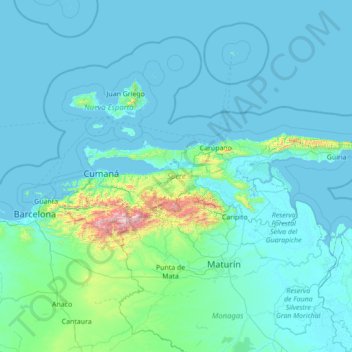
Name: Sucre State topographic map, elevation, terrain.
Location: Sucre State, Venezuela (10.03366 -64.56519 10.82428 -61.78974)
Average elevation: 109 m
Minimum elevation: -3 m
Maximum elevation: 2,480 m
Other topographic maps
Click on a map to view its topography, its elevation and its terrain.
Caracas
Venezuela > Capital District > Caracas
Cerro El Ávila (Mountain El Ávila) (Indigenous name: Waraira Repano), is a mountain in the mid-North of Venezuela. It rises next to Caracas and separates the city from the Caribbean Sea; The area's highest elevation is Pico Naiguatá, at 2,765 metres (9,072 ft) above sea level. It is considered the lungs of…
Average elevation: 858 m
Topo La Florida
Venezuela > Aragua State > Municipio Santos Michelena > La Florida
Average elevation: 980 m
Archipiélago Los Hermanos
Venezuela > Federal Dependencies > Archipiélago Los Hermanos
Average elevation: 0 m
Guiana Highlands
Venezuela > Bolivar State > Municipio Angostura
The Guiana Shield (French: Plateau des Guyanes, Bouclier guyanais; Dutch: Hoogland van Guyana, Guianaschild; Portuguese: Planalto das Guianas, Escudo das Guianas; Spanish: Escudo guayanés) is one of the three cratons of the South American Plate. It is a 1.7 billion-year-old Precambrian geological formation in…
Average elevation: 524 m
Mérida
Venezuela > Municipio Libertador
This city sits on a plateau nestled in the valley of the Chama River, which runs from end to end. The town of Mérida is located at an altitude of 1,600 metres (5,200 feet). As background on the horizon rises the country's highest summit: the Pico Bolívar with an altitude of 4,981 metres (16,342 feet).
Average elevation: 2,660 m
Valencia
Venezuela > Carabobo State > Municipio Valencia
The elevation of the city is 520 metres (1,710 feet).
Average elevation: 600 m
Parque Metropolitano Laguna de Las Peonías
Venezuela > Zulia State > Municipio Mara > Santa Cruz de Mara
Average elevation: 1 m
Mount Venamo
Venezuela > Bolivar State > Municipio Sifontes
A mountain in Guyana named Waukauyengtipu is often mistakenly synonymized with Mount Venamo, yet they are separate plateaus and each should be recognized by their respective, separate names. Most of the information about the true location and elevation of Cerro Venamo is taken from the results of Julian A.…
Average elevation: 1,293 m
Kukenán Tepui
Venezuela > Bolivar State > Parroquia Sección Capital Gran Sabana
Average elevation: 2,730 m