
Bridel topographic map
Interactive map
Click on the map to display elevation.
About this map
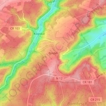
Name: Bridel topographic map, elevation, terrain.
Location: Bridel, Kopstal, Canton Capellen, 8133, Luxembourg (49.63714 6.06113 49.67714 6.10113)
Average elevation: 338 m
Minimum elevation: 237 m
Maximum elevation: 396 m
Other topographic maps
Click on a map to view its topography, its elevation and its terrain.
Mamer
Like Luxembourg City, Mamer (altitude 310 m) has a temperate climate with warm summers (average day temperature around 24 C, on occasion as high as 35 C) and chilly winters (daytime average 5 C but sometimes as low as -15 C at night). Rainfall is moderate, but on average it rains less than 10 days per month.…
Average elevation: 315 m