
Triesenberg topographic map
Interactive map
Click on the map to display elevation.
Triesenberg
Triesenberg is a municipality in Liechtenstein with a population of 2,636. Its area of 30 square kilometres (12 sq mi) makes it the largest municipality in Liechtenstein. The center of the municipality rests at an elevation of 884–1,000 metres (2,900–3,281 ft).
About this map
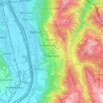
Name: Triesenberg topographic map, elevation, terrain.
Location: Triesenberg, Oberland, 9497, Liechtenstein (47.07814 9.53048 47.16653 9.63571)
Average elevation: 1,040 m
Minimum elevation: 443 m
Maximum elevation: 2,263 m
Other topographic maps
Click on a map to view its topography, its elevation and its terrain.