Odeda topographic map
Interactive map
Click on the map to display elevation.
About this map
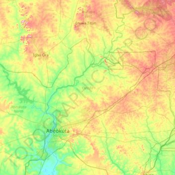
Name: Odeda topographic map, elevation, terrain.
Location: Odeda, Ogun State, Nigeria (7.13226 3.14209 7.49493 3.78986)
Average elevation: 129 m
Minimum elevation: 14 m
Maximum elevation: 331 m
Other topographic maps
Click on a map to view its topography, its elevation and its terrain.
Ijemo
Nigeria > Ogun State > Obafemi Owode
Ijemo, Obafemi Owode, Ogun State, Nigeria
Average elevation: 116 m
Agbohun
Nigeria > Ogun State > Obafemi Owode
Agbohun, Obafemi Owode, Ogun State, Nigeria
Average elevation: 128 m
Abeokuta
Nigeria > Ogun State > Abeokuta South
Abeokuta, Abeokuta South, Ogun State, 111101, Nigeria
Average elevation: 95 m
Abeokuta South
Abeokuta South, Ogun State, 111101, Nigeria
Average elevation: 97 m
Magboro
Nigeria > Ogun State > Obafemi Owode
Magboro, Obafemi Owode, Ogun State, 121006, Nigeria
Average elevation: 11 m