
Make a donation
Gear up for your next adventure:
As an Amazon Associate, this site earns from qualifying purchases at no extra cost to you.
Puerto Quito topographic map
Click on the map to display elevation.
Make a donation
Gear up for your next adventure:
As an Amazon Associate, this site earns from qualifying purchases at no extra cost to you.
About this map
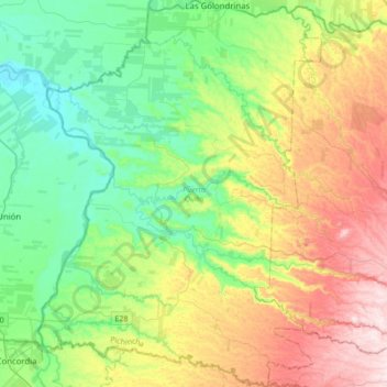
Name: Puerto Quito topographic map, elevation, terrain.
Location: Puerto Quito, Pichincha, 171204, Ecuador (-0.01544 -79.37090 0.32727 -79.11971)
Average elevation: 272 m
Minimum elevation: 75 m
Maximum elevation: 652 m
Make a donation
Gear up for your next adventure:
As an Amazon Associate, this site earns from qualifying purchases at no extra cost to you.
Other topographic maps
Click on a map to view its topography, its elevation and its terrain.
Cayambe
Ecuador > Pichincha > Cayambe > Cayambe
Cayambe or Volcán Cayambe is a volcano in Ecuador, in the Cordillera Central, a range of the Ecuadorian Andes. It is located in Pichincha Province, some 70 km (43 mi) northeast of Quito. It is the third-highest mountain in Ecuador, at an elevation of 5,790 m (18,996 ft) above sea level.
Average elevation: 5,246 m
Make a donation
Gear up for your next adventure:
As an Amazon Associate, this site earns from qualifying purchases at no extra cost to you.
Make a donation
Gear up for your next adventure:
As an Amazon Associate, this site earns from qualifying purchases at no extra cost to you.
Volcán Cotopaxi
Ecuador > Pichincha > Machachi > Machachi
In the late 20th century, summiting Cotopaxi became a major tourist draw. The José F. Ribas Refuge (Refugio José Félix Ribas) was built in 1971 at an elevation of 4,864 m (15,960 ft) and enlarged in 2005.
Average elevation: 5,021 m
Make a donation
Gear up for your next adventure:
As an Amazon Associate, this site earns from qualifying purchases at no extra cost to you.
Make a donation
Gear up for your next adventure:
As an Amazon Associate, this site earns from qualifying purchases at no extra cost to you.