Beclean topographic map
Click on the map to display elevation.
About this map
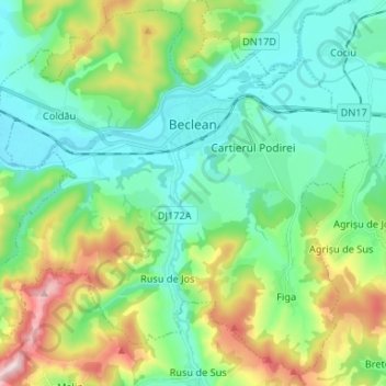
Name: Beclean topographic map, elevation, terrain.
Location: Beclean, Bistrița-Năsăud, Romania (47.12168 24.10808 47.20646 24.23965)
Average elevation: 344 m
Minimum elevation: 246 m
Maximum elevation: 600 m
Other topographic maps
Click on a map to view its topography, its elevation and its terrain.
Bistrița
According to Köppen climate classification, Bistrița has a humid continental climate(Dfb) with cold, snowy winters and warm, rainy summers. Due to its modest elevation, Bistrița has one of the coldest climates in Romania.
Average elevation: 463 m
Bistrița
According to Köppen climate classification, Bistrița has a humid continental climate(Dfb) with cold, snowy winters and warm, rainy summers. Due to its modest elevation, Bistrița has one of the coldest climates in Romania.
Average elevation: 463 m


Tihuța Pass
Romania > Bistrița-Năsăud > Tiha Bârgăului
Today the pass is home to Hotel "Castel Dracula"; located at an elevation of 1,116 m (3,661 ft), the hotel was built in 1976 and adopted its current name after 1989. The hotel has become quite an attraction due to its architectural style of a medieval villa, as well as the connection to the novel. In 2018 the…
Average elevation: 1,104 m