
Make a donation
Gear up for your next adventure:
As an Amazon Associate, this site earns from qualifying purchases at no extra cost to you.
Strugureni topographic map
Click on the map to display elevation.
Make a donation
Gear up for your next adventure:
As an Amazon Associate, this site earns from qualifying purchases at no extra cost to you.
About this map
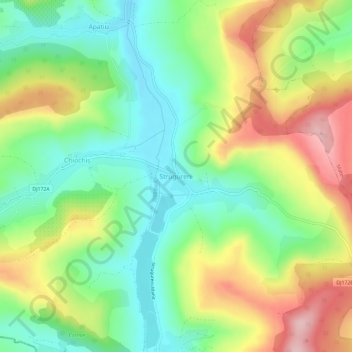
Name: Strugureni topographic map, elevation, terrain.
Location: Strugureni, Chiochiș, Bistrița-Năsăud, 427054, Romania (46.96263 24.17910 47.00263 24.21910)
Average elevation: 404 m
Minimum elevation: 315 m
Maximum elevation: 539 m
Make a donation
Gear up for your next adventure:
As an Amazon Associate, this site earns from qualifying purchases at no extra cost to you.
Other topographic maps
Click on a map to view its topography, its elevation and its terrain.
Bistrița
According to Köppen climate classification, Bistrița has a humid continental climate(Dfb) with cold, snowy winters and warm, rainy summers. Due to its modest elevation, Bistrița has one of the coldest climates in Romania.
Average elevation: 429 m
Make a donation
Gear up for your next adventure:
As an Amazon Associate, this site earns from qualifying purchases at no extra cost to you.
Bistrița
According to Köppen climate classification, Bistrița has a humid continental climate(Dfb) with cold, snowy winters and warm, rainy summers. Due to its modest elevation, Bistrița has one of the coldest climates in Romania.
Average elevation: 429 m
Bistrița
Due to its modest elevation, Bistrița has one of the coldest climates in Romania.
Average elevation: 429 m
Make a donation
Gear up for your next adventure:
As an Amazon Associate, this site earns from qualifying purchases at no extra cost to you.
Make a donation
Gear up for your next adventure:
As an Amazon Associate, this site earns from qualifying purchases at no extra cost to you.
Make a donation
Gear up for your next adventure:
As an Amazon Associate, this site earns from qualifying purchases at no extra cost to you.