
Lyndon topographic map
Interactive map
Click on the map to display elevation.
Lyndon
The highest point in Lyndon is Diamond Hill in the southwest, with an elevation of slightly greater than 1,640 feet (500 m).
About this map
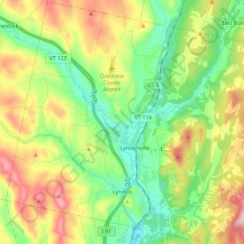
Name: Lyndon topographic map, elevation, terrain.
Location: Lyndon, Caledonia County, Vermont, United States (44.49135 -72.08354 44.59842 -71.93155)
Average elevation: 317 m
Minimum elevation: 183 m
Maximum elevation: 542 m
Other topographic maps
Click on a map to view its topography, its elevation and its terrain.
Saint Johnsbury
United States > Vermont > Caledonia County > Saint Johnsbury
St. Johnsbury is located at 44°25′N 72°01′W / 44.417°N 72.017°W / 44.417; -72.017, elevation 212.4 m (697 ft). According to the United States Census Bureau, the town has a total area of 36.8 square miles (95.2 km2), of which 36.4 square miles (94.3 km2) is land and 0.35 square miles (0.9 km2),…
Average elevation: 311 m
Sutton
United States > Vermont > Caledonia County > Sutton
The highest point in Sutton is the summit of Mount Hor in the northern corner of town, with an elevation of 2,656 feet (809.5 m) above sea level. The modest elevation of this town gives it a slightly cooler and wetter climate than nearby towns such as St. Johnsbury. Annual snowfall averages well over 100…
Average elevation: 459 m
Sheffield
United States > Vermont > Caledonia County
The highest point in Sheffield is an unnamed summit in the northeast corner of town, with an elevation of 2,543 feet (775 m) above sea level, between Granby Mountain and Norris Mountain.
Average elevation: 471 m
Wheelock
United States > Vermont > Caledonia County
The highest point in town is Wheelock Mountain, with an elevation of 2,782 feet (848 m).
Average elevation: 412 m