
Melle topographic map
Interactive map
Click on the map to display elevation.
About this map
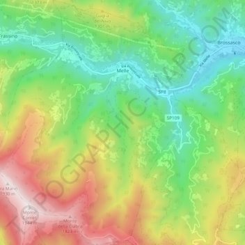
Name: Melle topographic map, elevation, terrain.
Location: Melle, Cuneo, Piedmont, Italy (44.51395 7.26797 44.58150 7.35055)
Average elevation: 1,104 m
Minimum elevation: 586 m
Maximum elevation: 1,941 m
Other topographic maps
Click on a map to view its topography, its elevation and its terrain.
Madonna della Neve
Italy > Piedmont > Cuneo > Clavesana
Madonna della Neve, Clavesana, Cuneo, Piedmont, 12061, Italy
Average elevation: 329 m
Monte Pennino
Italy > Piedmont > Cuneo > Garessio
Monte Pennino, Garessio, Cuneo, Piedmont, 12075, Italy
Average elevation: 1,068 m
Costigliole Saluzzo
Costigliole Saluzzo, Cuneo, Piedmont, Italy
Average elevation: 501 m
Pellerina
Italy > Piedmont > Cuneo > Chiusa di Pesio
Pellerina, Chiusa di Pesio, Cuneo, Piedmont, Italy
Average elevation: 1,693 m
Colle Fauniera
Italy > Piedmont > Cuneo > Demonte
Colle Fauniera, Demonte, Cuneo, Piedmont, Italy
Average elevation: 2,315 m
Col Agnel / Colle dell'Agnello
Italy > Piedmont > Cuneo > Pontechianale
Col Agnel / Colle dell'Agnello, Pontechianale, Cuneo, Piedmont, Italy
Average elevation: 2,700 m
Prato Nevoso
Prato Nevoso, Frabosa Sottana, Cuneo, Piedmont, 12083, Italy
Average elevation: 1,436 m
Monte Brancetta
Italy > Piedmont > Cuneo > Argentera
Monte Brancetta, Argentera, Cuneo, Piedmont, Italy
Average elevation: 2,467 m
Bric del Solio
Italy > Piedmont > Cuneo > San Michele Mondovì
Bric del Solio, San Michele Mondovì, Cuneo, Piedmont, Italy
Average elevation: 646 m
Monviso
Italy > Piedmont > Cuneo > Pontechianale
Monviso, Pontechianale, Cuneo, Piedmont, Italy
Average elevation: 2,985 m
Chiusa di Pesio
Chiusa di Pesio, Cuneo, Piedmont, 12013, Italy
Average elevation: 1,143 m
Pratolungo
Italy > Piedmont > Cuneo > Pratolungo
Pratolungo, Vinadio, Cuneo, Piedmont, Italy
Average elevation: 1,303 m
Santo Stefano Belbo
Italy > Piedmont > Cuneo > Santo Stefano Belbo
Santo Stefano Belbo, Cuneo, Piedmont, 12058, Italy
Average elevation: 323 m
F.ne Scaglione
Italy > Piedmont > Cuneo > Santo Stefano Belbo > F.ne Scaglione
F.ne Scaglione, Santo Stefano Belbo, Cuneo, Piedmont, 12053, Italy
Average elevation: 330 m
Monforte d'Alba
Monforte d'Alba, Cuneo, Piedmont, Italy
Average elevation: 373 m
Castelletto
Castelletto, Roccasparvera, Cuneo, Piedmont, Italy
Average elevation: 819 m
Sorgente del Po
Italy > Piedmont > Cuneo > Crissolo > Pian del Re
Sorgente del Po, Via Pian del Re, Pian del Re, Crissolo, Cuneo, Piedmont, Italy
Average elevation: 2,314 m
Limone Piemonte
Limone Piemonte, Cuneo, Piedmont, 12015, Italy
Average elevation: 1,619 m