
Black Esk topographic map
Interactive map
Click on the map to display elevation.
About this map
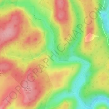
Name: Black Esk topographic map, elevation, terrain.
Location: Black Esk, Dumfries and Galloway, Scotland, United Kingdom (55.20572 -3.23134 55.23338 -3.19211)
Average elevation: 231 m
Minimum elevation: 161 m
Maximum elevation: 286 m
Dumfries and Galloway trails, hiking, mountain biking, running and outdoor activities
Other topographic maps
Click on a map to view its topography, its elevation and its terrain.
Merrick
United Kingdom > Scotland > Dumfries and Galloway
The Merrick, or simply Merrick (Scottish Gaelic: A' Mhearag), is a mountain in the Range of the Awful Hand, a sub-range of the Galloway Hills range, part of the Southern Uplands of Scotland. The summit elevation is 843 metres (2,766 feet), making it the highest mountain in the Southern Uplands and southern…
Average elevation: 591 m
Eskdalemuir
United Kingdom > Scotland > Dumfries and Galloway
In spite of it being located inland, the dull and wet nature of the climate due to the elevation leads to chilly summers that are colder than more northerly locations such as Glasgow and Edinburgh. The inland nature of the climate is more manifest during winter months with frosts being common, and the average…
Average elevation: 246 m