Geolocate

Gomoa Central District topographic map

Interactive map

Click on the map to display elevation.

About this map

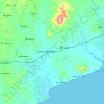
Name: Gomoa Central District topographic map, elevation, terrain.

Location: Gomoa Central District, Central Region, Ghana (5.27450 -0.78208 5.43434 -0.64240)

Average elevation: 35 m

Minimum elevation: -1 m

Maximum elevation: 255 m

Other topographic maps

Click on a map to view its topography, its elevation and its terrain.

Breman Asikuma

Ghana > Central Region > Asikuma/Odoben/Brakwa District

Breman Asikuma, Asikuma/Odoben/Brakwa District, Central Region, Ghana

Average elevation: 85 m

Komenda

Ghana > Central Region > Komenda/Edina/Eguafo/Abirem Municipal District

Komenda, Komenda/Edina/Eguafo/Abirem Municipal District, Central Region, Ghana

Average elevation: 5 m

Upper Denkyira West District

Ghana > Central Region

Upper Denkyira West District, Central Region, Ghana

Average elevation: 142 m

Cape Coast

Ghana > Central Region > Cape Coast Metropolitan District

Cape Coast, Cape Coast Metropolitan District, Central Region, CC-008-3586, Ghana

Average elevation: 22 m

Upper Denkyira East Municipal District

Ghana > Central Region > Upper Denkyira East Municipal District

Upper Denkyira East Municipal District, Central Region, Ghana

Average elevation: 140 m

Awutu Breku

Ghana > Central Region > Awutu Senya West District

Awutu Breku, Awutu Senya West District, Central Region, Ghana

Average elevation: 103 m

Kasoa

Ghana > Central Region > Gomoa East District

Kasoa, Gomoa East District, Central Region, Ghana

Average elevation: 31 m

Elmina

Ghana > Central Region > Komenda/Edina/Eguafo/Abirem Municipal District

Elmina, Komenda/Edina/Eguafo/Abirem Municipal District, Central Region, Ghana

Average elevation: 6 m

Ayanfuri

Ghana > Central Region > Ayanfuri

Ayanfuri, Central Region, Ghana

Average elevation: 147 m

Awutu Bereku

Ghana > Central Region > Awutu Senya West District

Awutu Bereku, Awutu Senya West District, Central Region, Ghana

Average elevation: 57 m