
Make a donation
Gear up for your next adventure:
As an Amazon Associate, this site earns from qualifying purchases at no extra cost to you.
Mount Lyall topographic map
Click on the map to display elevation.
Make a donation
Gear up for your next adventure:
As an Amazon Associate, this site earns from qualifying purchases at no extra cost to you.
About this map
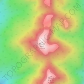
Name: Mount Lyall topographic map, elevation, terrain.
Location: Mount Lyall, Southland District, Southland, New Zealand (-45.70764 166.68383 -45.70754 166.68393)
Average elevation: 575 m
Minimum elevation: 172 m
Maximum elevation: 974 m
Make a donation
Gear up for your next adventure:
As an Amazon Associate, this site earns from qualifying purchases at no extra cost to you.
Other topographic maps
Click on a map to view its topography, its elevation and its terrain.
Doubtful Sound
New Zealand > Southland > Southland District > Fiordland Community
Average elevation: 560 m
Stewart Island / Rakiura Community
New Zealand > Southland > Southland District
Average elevation: 63 m
Milford Sound
New Zealand > Southland > Southland District > Fiordland Community
Average elevation: 655 m
Make a donation
Gear up for your next adventure:
As an Amazon Associate, this site earns from qualifying purchases at no extra cost to you.
Takitimu Mountains
New Zealand > Southland > Southland District > Wallace Takitimu Community
Average elevation: 828 m
Te Puhi-a-noa / Murchison Mountains
New Zealand > Southland > Southland District
Average elevation: 851 m
Make a donation
Gear up for your next adventure:
As an Amazon Associate, this site earns from qualifying purchases at no extra cost to you.
Darran Mountains
New Zealand > Southland > Southland District > Fiordland Community
Average elevation: 911 m
Skippers Range
New Zealand > Southland > Southland District > Fiordland Community
Average elevation: 595 m
Te Rau / Garvie Mountains
New Zealand > Southland > Southland District > Cromwell Community
Average elevation: 1,393 m
Make a donation
Gear up for your next adventure:
As an Amazon Associate, this site earns from qualifying purchases at no extra cost to you.
Wick Mountains
New Zealand > Southland > Southland District > Fiordland Community
Average elevation: 1,185 m
Make a donation
Gear up for your next adventure:
As an Amazon Associate, this site earns from qualifying purchases at no extra cost to you.
Mararoa River
New Zealand > Southland > Southland District > Fiordland Community
Average elevation: 681 m
Waikawa River
New Zealand > Southland > Southland District > Waihopai Toetoe Community
Average elevation: 134 m
Lake Quill
New Zealand > Southland > Southland District > Fiordland Community
Average elevation: 1,228 m
Make a donation
Gear up for your next adventure:
As an Amazon Associate, this site earns from qualifying purchases at no extra cost to you.
Lake Te Au
New Zealand > Southland > Southland District > Fiordland Community
Average elevation: 597 m
Donne Glacier
New Zealand > Southland > Southland District > Fiordland Community
Average elevation: 1,826 m
Age Glacier
New Zealand > Southland > Southland District > Fiordland Community
Average elevation: 1,753 m
Eyre Mountains / Taka Ra Haka Conservation Park
New Zealand > Southland > Southland District
Average elevation: 810 m
Make a donation
Gear up for your next adventure:
As an Amazon Associate, this site earns from qualifying purchases at no extra cost to you.
Pembroke Glacier
New Zealand > Southland > Southland District > Fiordland Community
Average elevation: 1,211 m
Make a donation
Gear up for your next adventure:
As an Amazon Associate, this site earns from qualifying purchases at no extra cost to you.
Cleddau River
New Zealand > Southland > Southland District > Fiordland Community
Average elevation: 800 m
Make a donation
Gear up for your next adventure:
As an Amazon Associate, this site earns from qualifying purchases at no extra cost to you.
Lake Innes
New Zealand > Southland > Southland District > Tuatapere Te Waewae Community
Average elevation: 223 m
Pitt River
New Zealand > Southland > Southland District > Fiordland Community
Average elevation: 706 m
Make a donation
Gear up for your next adventure:
As an Amazon Associate, this site earns from qualifying purchases at no extra cost to you.