
Make a donation
Gear up for your next adventure:
As an Amazon Associate, this site earns from qualifying purchases at no extra cost to you.
Fiordland Community topographic map
Click on the map to display elevation.
Make a donation
Gear up for your next adventure:
As an Amazon Associate, this site earns from qualifying purchases at no extra cost to you.
About this map
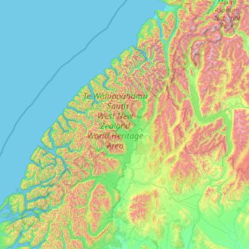
Name: Fiordland Community topographic map, elevation, terrain.
Average elevation: 525 m
Minimum elevation: -1 m
Maximum elevation: 2,696 m
Make a donation
Gear up for your next adventure:
As an Amazon Associate, this site earns from qualifying purchases at no extra cost to you.
Other topographic maps
Click on a map to view its topography, its elevation and its terrain.
Mitre Peak
New Zealand > Southland > Southland District > Fiordland Community
Average elevation: 657 m
Riverton
New Zealand > Southland > Southland District > Oraka Aparima Community
Average elevation: 16 m
Make a donation
Gear up for your next adventure:
As an Amazon Associate, this site earns from qualifying purchases at no extra cost to you.
Roslyn Bush
New Zealand > Southland > Southland District > Waihopai Toetoe Community
Average elevation: 29 m
Nightcaps
New Zealand > Southland > Southland District > Wallace Takitimu Community
Average elevation: 183 m
Clifden
New Zealand > Southland > Southland District > Tuatapere Te Waewae Community
Average elevation: 70 m
Make a donation
Gear up for your next adventure:
As an Amazon Associate, this site earns from qualifying purchases at no extra cost to you.
Edendale
New Zealand > Southland > Southland District > Waihopai Toetoe Community
Average elevation: 41 m
Pukemaori
New Zealand > Southland > Southland District > Tuatapere Te Waewae Community
Average elevation: 124 m
Make a donation
Gear up for your next adventure:
As an Amazon Associate, this site earns from qualifying purchases at no extra cost to you.
Makarewa Junction
New Zealand > Southland > Southland District > Oreti Community
Average elevation: 17 m
Otahu Flat
New Zealand > Southland > Southland District > Tuatapere Te Waewae Community
Average elevation: 90 m
Tūātapere
New Zealand > Southland > Southland District > Tuatapere Te Waewae Community
Average elevation: 41 m
Make a donation
Gear up for your next adventure:
As an Amazon Associate, this site earns from qualifying purchases at no extra cost to you.
Mount Tūtoko
New Zealand > Southland > Southland District > Fiordland Community
Average elevation: 1,892 m
Mount Anglem / Hananui
New Zealand > Southland > Southland District > Stewart Island / Rakiura Community
Mount Anglem / Hananui is the highest point on New Zealand's Stewart Island / Rakiura. It is located 20 kilometres (12 mi) northwest of Oban, close to the island's north coast, and rises to an elevation of 980 metres (3,215 ft) above sea level. Following the passage of the Ngāi Tahu Claims Settlement Act…
Average elevation: 668 m
Mount Christina
New Zealand > Southland > Southland District > Fiordland Community
Average elevation: 1,574 m
Make a donation
Gear up for your next adventure:
As an Amazon Associate, this site earns from qualifying purchases at no extra cost to you.
Takitimu Mountains
New Zealand > Southland > Southland District > Wallace Takitimu Community
Average elevation: 828 m
Te Puhi-a-noa / Murchison Mountains
New Zealand > Southland > Southland District
Average elevation: 851 m
Make a donation
Gear up for your next adventure:
As an Amazon Associate, this site earns from qualifying purchases at no extra cost to you.
Darran Mountains
New Zealand > Southland > Southland District > Fiordland Community
Average elevation: 911 m
Skippers Range
New Zealand > Southland > Southland District > Fiordland Community
Average elevation: 595 m
Te Rau / Garvie Mountains
New Zealand > Southland > Southland District > Cromwell Community
Average elevation: 1,393 m
Make a donation
Gear up for your next adventure:
As an Amazon Associate, this site earns from qualifying purchases at no extra cost to you.
Wick Mountains
New Zealand > Southland > Southland District > Fiordland Community
Average elevation: 1,185 m
Make a donation
Gear up for your next adventure:
As an Amazon Associate, this site earns from qualifying purchases at no extra cost to you.
Mararoa River
New Zealand > Southland > Southland District > Fiordland Community
Average elevation: 681 m
Waikawa River
New Zealand > Southland > Southland District > Waihopai Toetoe Community
Average elevation: 134 m
Lake Quill
New Zealand > Southland > Southland District > Fiordland Community
Average elevation: 1,228 m
Lake Te Au
New Zealand > Southland > Southland District > Fiordland Community
Average elevation: 597 m
Make a donation
Gear up for your next adventure:
As an Amazon Associate, this site earns from qualifying purchases at no extra cost to you.
Age Glacier
New Zealand > Southland > Southland District > Fiordland Community
Average elevation: 1,753 m
Pembroke Glacier
New Zealand > Southland > Southland District > Fiordland Community
Average elevation: 1,211 m
Make a donation
Gear up for your next adventure:
As an Amazon Associate, this site earns from qualifying purchases at no extra cost to you.
Oban
New Zealand > Southland > Southland District > Stewart Island / Rakiura Community
Average elevation: 23 m
Mount Elliot
New Zealand > Southland > Southland District > Fiordland Community
Average elevation: 1,110 m
Waimānu / Stirling Falls
New Zealand > Southland > Southland District > Fiordland Community
Average elevation: 423 m
Nightcaps
New Zealand > Southland > Southland District > Wallace Takitimu Community
Average elevation: 183 m
Make a donation
Gear up for your next adventure:
As an Amazon Associate, this site earns from qualifying purchases at no extra cost to you.
Lake Innes
New Zealand > Southland > Southland District > Tuatapere Te Waewae Community
Average elevation: 223 m
Eldrig Peak
New Zealand > Southland > Southland District > Fiordland Community
Average elevation: 1,155 m
Make a donation
Gear up for your next adventure:
As an Amazon Associate, this site earns from qualifying purchases at no extra cost to you.
Oban
New Zealand > Southland > Southland District > Stewart Island / Rakiura Community
Average elevation: 23 m
Hineteawa / Bowen Falls
New Zealand > Southland > Southland District > Fiordland Community
Average elevation: 232 m
Island Hill
New Zealand > Southland > Southland District > Stewart Island / Rakiura Community
Average elevation: 50 m
Make a donation
Gear up for your next adventure:
As an Amazon Associate, this site earns from qualifying purchases at no extra cost to you.
Twin Sisters
New Zealand > Southland > Southland District > Fiordland Community
Average elevation: 1,039 m
Pearl Harbour
New Zealand > Southland > Southland District > Fiordland Community > Manapouri
Average elevation: 212 m
Merrivale
New Zealand > Southland > Southland District > Tuatapere Te Waewae Community
Average elevation: 192 m
Make a donation
Gear up for your next adventure:
As an Amazon Associate, this site earns from qualifying purchases at no extra cost to you.
Mount Owen
New Zealand > Southland > Southland District > Fiordland Community
Average elevation: 1,269 m
Sutherland Falls
New Zealand > Southland > Southland District > Fiordland Community
Average elevation: 1,006 m
Mitre Peak
New Zealand > Southland > Southland District > Fiordland Community
Average elevation: 657 m
Make a donation
Gear up for your next adventure:
As an Amazon Associate, this site earns from qualifying purchases at no extra cost to you.
White Peak
New Zealand > Southland > Southland District > Tuatapere Te Waewae Community
Average elevation: 1,153 m
Blackmount
New Zealand > Southland > Southland District > Tuatapere Te Waewae Community > Blackmount
Average elevation: 170 m
Waikawa
New Zealand > Southland > Southland District > Waihopai Toetoe Community > Waikawa
Average elevation: 39 m
Make a donation
Gear up for your next adventure:
As an Amazon Associate, this site earns from qualifying purchases at no extra cost to you.
Mount Makere
New Zealand > Southland > Southland District > Fiordland Community
Average elevation: 1,433 m
Make a donation
Gear up for your next adventure:
As an Amazon Associate, this site earns from qualifying purchases at no extra cost to you.
Turner Falls
New Zealand > Southland > Southland District > Fiordland Community
Average elevation: 1,335 m
The Downs
New Zealand > Southland > Southland District > Tuatapere Te Waewae Community
Average elevation: 34 m