
Montgomery County topographic map
Interactive map
Click on the map to display elevation.
About this map
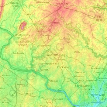
Name: Montgomery County topographic map, elevation, terrain.
Location: Montgomery County, Maryland, United States (38.93435 -77.52738 39.35432 -76.88766)
Average elevation: 120 m
Minimum elevation: -2 m
Maximum elevation: 368 m
According to the U.S. Census Bureau, the county has a total area of 507 square miles (1,310 km2), of which 491 square miles (1,270 km2) is land and 16 square miles (41 km2) (3.1%) is water. Montgomery County lies entirely inside the Piedmont plateau. The topography is generally rolling. Elevations range from a low of near sea level along the Potomac River to about 875 feet in the northernmost portion of the county north of Damascus. Relief between valley bottoms and hilltops is several hundred feet.
Other topographic maps
Click on a map to view its topography, its elevation and its terrain.
Annapolis
United States > Maryland > Anne Arundel County
Annapolis, Anne Arundel County, Maryland, United States
Average elevation: 8 m
Baltimore
United States > Maryland > Baltimore
Baltimore, Maryland, 21233, United States
Average elevation: 65 m
Middle East
United States > Maryland > Baltimore
Middle East, Baltimore, Maryland, United States
Average elevation: 29 m
Salisbury
United States > Maryland > Wicomico County
Salisbury, Wicomico County, Maryland, United States
Average elevation: 12 m
Frederick County
Frederick County, Maryland, United States
Average elevation: 186 m
Hickory Hills
United States > Maryland > Calvert County
Hickory Hills, Calvert County, Maryland, 20689, United States
Average elevation: 25 m
Bel Air
United States > Maryland > Harford County
Bel Air, Harford County, Maryland, 21014, United States
Average elevation: 103 m
Ellicott City
United States > Maryland > Howard County
Ellicott City, Howard County, Maryland, 21043, United States
Average elevation: 119 m
Rockville
United States > Maryland > Montgomery County
Rockville, Montgomery County, Maryland, United States
Average elevation: 122 m
Prince George's County
Prince George's County, Maryland, United States
Average elevation: 45 m
Fruitland
United States > Maryland > Wicomico County
Fruitland, Wicomico County, Maryland, 21826, United States
Average elevation: 11 m
Glenn Dale
United States > Maryland > Prince George's County
Glenn Dale, Prince George's County, Maryland, 20769, United States
Average elevation: 53 m
Perry Hall
United States > Maryland > Baltimore County > Perry Hall
Perry Hall, Baltimore County, Maryland, 21236, United States
Average elevation: 73 m
Bohemias Mills
United States > Maryland > Cecil County
Bohemias Mills, Cecil County, Maryland, 21912, United States
Average elevation: 16 m
Elkmore
United States > Maryland > Cecil County
Elkmore, Cecil County, Maryland, United States
Average elevation: 17 m
Chesapeake Bay
Chesapeake Bay, Maryland, 23459, United States
Average elevation: 33 m
Cumberland
United States > Maryland > Allegany County
Cumberland, Allegany County, Maryland, 21502, United States
Average elevation: 264 m
North Laurel
United States > Maryland > Howard County
North Laurel, Howard County, Maryland, 20725, United States
Average elevation: 71 m
Linden Estates
United States > Maryland > Carroll County
Linden Estates, Carroll County, Maryland, 21158, United States
Average elevation: 206 m
Edgewater
United States > Maryland > Anne Arundel County > Edgewater
Edgewater, Anne Arundel County, Maryland, United States
Average elevation: 7 m
Perry Hall
United States > Maryland > Baltimore County
Perry Hall, Baltimore County, Maryland, 21236, United States
Average elevation: 72 m
Tilghman Island
United States > Maryland > Talbot County
Tilghman Island, Talbot County, Maryland, 21671, United States
Average elevation: 1 m
Deale
United States > Maryland > Anne Arundel County
Deale, Anne Arundel County, Maryland, 20751, United States
Average elevation: 5 m
Wheaton
United States > Maryland > Montgomery County > Wheaton
Wheaton, Montgomery County, Maryland, 20902, United States
Average elevation: 107 m
West River
United States > Maryland > Anne Arundel County
West River, Anne Arundel County, Maryland, 20776, United States
Average elevation: 36 m
Oak Park
United States > Maryland > Frederick County
Oak Park, Frederick County, Maryland, 21173, United States
Average elevation: 217 m
Shady Side
United States > Maryland > Anne Arundel County
Shady Side, Anne Arundel County, Maryland, 20764, United States
Average elevation: 1 m
Ocean Pines
United States > Maryland > Worcester County
Ocean Pines, Worcester County, Maryland, 21811, United States
Average elevation: 3 m
Cedarville State Forest
United States > Maryland > Charles County > Brandywine
Cedarville State Forest, 10201, Brandywine, Charles County, Maryland, 20613, United States
Average elevation: 59 m
Mariners Point
United States > Maryland > Anne Arundel County > Annapolis
Mariners Point, Annapolis, Anne Arundel County, Maryland, 21403, United States
Average elevation: 7 m
Harford County
Harford County, Maryland, United States
Average elevation: 70 m
Hampton
United States > Maryland > Baltimore County > Hampton
Hampton, Baltimore County, Maryland, United States
Average elevation: 108 m
Urbana
United States > Maryland > Frederick County
Urbana, Frederick County, Maryland, United States
Average elevation: 131 m
Smith Island
United States > Maryland > Somerset County > Rhodes Point
Smith Island, Rhodes Point, Somerset County, Maryland, United States
Average elevation: 0 m
Stevensville
United States > Maryland > Queen Anne's County > Stevensville
Stevensville, Queen Anne's County, Maryland, United States
Average elevation: 2 m
Monrovia
United States > Maryland > Frederick County
Monrovia, Frederick County, Maryland, 21174, United States
Average elevation: 153 m
Hyattsville
United States > Maryland > Prince George's County
Hyattsville, Prince George's County, Maryland, 20781, United States
Average elevation: 61 m
Little John
United States > Maryland > Anne Arundel County
Little John, Anne Arundel County, Maryland, 21405, United States
Average elevation: 16 m
La Plata
United States > Maryland > Charles County
La Plata, Charles County, Maryland, 20646, United States
Average elevation: 48 m
Wetherfield
United States > Maryland > Baltimore County
Wetherfield, Baltimore County, Maryland, United States
Average elevation: 96 m
Hillcrest Heights
United States > Maryland > Prince George's County
Hillcrest Heights, Prince George's County, Maryland, 20728, United States
Average elevation: 61 m
National Harbor
United States > Maryland > Prince George's County
National Harbor, Prince George's County, Maryland, 20745, United States
Average elevation: 24 m
White Plains
United States > Maryland > Wicomico County
White Plains, Wicomico County, Maryland, 21804, United States
Average elevation: 14 m
Patapsco Valley State Park
United States > Maryland > Howard County > Ilchester
Patapsco Valley State Park, Ilchester, Howard County, Maryland, 21163, United States
Average elevation: 131 m
Greenbelt Park
United States > Maryland > Prince George's County > Greenbelt
Greenbelt Park, 6565, Greenbelt, Prince George's County, Maryland, 20770, United States
Average elevation: 40 m
Weverton
United States > Maryland > Washington County
Weverton, Washington County, Maryland, 21758, United States
Average elevation: 153 m
Golts
United States > Maryland > Kent County
Golts, Kent County, Maryland, United States
Average elevation: 22 m
Carderock
United States > Maryland > Montgomery County > Potomac
Carderock, Potomac, Montgomery County, Maryland, 20818, United States
Average elevation: 58 m
Towson
United States > Maryland > Baltimore County
Towson, Baltimore County, Maryland, 21252, United States
Average elevation: 101 m
Gambrills
United States > Maryland > Anne Arundel County > Gambrills
Gambrills, Anne Arundel County, Maryland, United States
Average elevation: 37 m