Geolocate

Malaysia topographic map

Interactive map

Click on the map to display elevation.

About this map

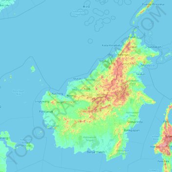
Name: Malaysia topographic map, elevation, terrain.

Location: Malaysia (-5.10762 105.34719 9.89238 120.34719)

Average elevation: 80 m

Minimum elevation: -3 m

Maximum elevation: 3,432 m

Other topographic maps

Click on a map to view its topography, its elevation and its terrain.

Kota Kinabalu

Malaysia > Sabah

Average elevation: 86 m

Ipoh

Malaysia > Perak > Majlis Bandaraya Ipoh

Average elevation: 205 m

Bintulu

Malaysia > Sarawak > Bintulu

Average elevation: 18 m

Kuala Lumpur

Malaysia > Kuala Lumpur

Located in the centre of Selangor state, Kuala Lumpur was a territory of Selangor State Government. In 1974, Kuala Lumpur was split off from Selangor to form the first Federal Territory governed directly by the Malaysian federal government. Its location in the most developed state on the west coast of…

Average elevation: 127 m

Klang

Malaysia > Selangor > Klang

Average elevation: 13 m

Puchong

Malaysia > Selangor > Subang Jaya City Council

Average elevation: 38 m

Johor Bahru

Malaysia > Johor

Average elevation: 23 m

Gunung Panchor

Malaysia > Kelantan

Average elevation: 25 m

Pahang

Malaysia > Pahang

The highest peak, Mount Tahan, reaches 2,187 m (7,175 ft) in elevation, which is also the highest point in the Peninsular Malaysia. The climate is temperate enough to have distinct temperature variations year round, and much of the highlands are covered with tropical rainforest. Pahang is home to Malaysia's…

Average elevation: 90 m

Penang Island

Malaysia > Penang Island

Penang Island is irregularly shaped, with a hilly and mostly forested interior; its coastal plains are narrow, the most extensive of which is at the northeastern cape. With a height of 833 m (2,733 ft), Penang Hill, at the centre of the island, is the tallest point within Penang. From a small settlement at the…

Average elevation: 117 m

Sarawak River

Malaysia > Sarawak > Kuching

Average elevation: 6 m

Pulai

Malaysia > Johor > Iskandar Puteri

Average elevation: 25 m

Selama (Perak)

Malaysia > Perak

Average elevation: 23 m

Triang River

Malaysia > Pahang

Average elevation: 37 m

Sungai Air Tawar

Malaysia > Kedah

Average elevation: 152 m

Kuching

Malaysia > Sarawak > Kuching

Average elevation: 17 m

Johor Bahru

Malaysia > Johor

Average elevation: 23 m

Sibu

Malaysia > Sarawak > Sibu

Sibu is located near the Rajang delta at the confluence of Rajang and Igan rivers. Peat swamp forests and alluvial plains are particularly prevalent in the Sibu Division. Sibu is located on a deep peat soil, which has caused problems in infrastructure development because buildings and roads slowly sink into…

Average elevation: 10 m

Kangar

Malaysia > Perlis

Average elevation: 28 m

Seremban

Malaysia > Negeri Sembilan

Average elevation: 168 m

Kampung Badang

Malaysia > Kelantan

Average elevation: 5 m

Bukit Batu

Malaysia > Johor > Kulai

Average elevation: 63 m

Kuala Kubu Bharu

Malaysia > Selangor

Average elevation: 433 m

Sungai Cereh

Malaysia > Pahang

Average elevation: 66 m

Gunung Angsi

Malaysia > Negeri Sembilan

Part of the Titiwangsa Mountains, it is the seventh tallest mountain in the state, behind Mts. Besar Hantu, Hantu Kecil, Telapak Buruk, Berembun and Datuk, with an elevation of 2,707 feet (825 m).

Average elevation: 552 m

Sungai Bantang

Malaysia > Johor

Average elevation: 141 m

Kampung Sungai Dendang

Malaysia > Perak

Average elevation: 26 m

Kuala Lumpur

Malaysia > Kuala Lumpur

Located in the centre of Selangor state, Kuala Lumpur was a territory of Selangor State Government. In 1974, Kuala Lumpur was split off from Selangor to form the first Federal Territory governed directly by the Malaysian federal government. Its location in the most developed state on the west coast of…

Average elevation: 127 m

Air Terjun Sekayu

Malaysia > Terengganu

Average elevation: 137 m

Sungai Petani

Malaysia > Kedah

Average elevation: 45 m

Mahang River

Malaysia > Negeri Sembilan > Batang Benar

Average elevation: 64 m

Bukit Batu

Malaysia > Johor > Kulai

Average elevation: 63 m

Alor Setar

Malaysia > Kedah

Average elevation: 9 m

Mata Ayer

Malaysia > Perlis

Average elevation: 15 m

Batu Pahat

Malaysia > Johor

Average elevation: 10 m

Tenang Stesen

Malaysia > Johor > Kampung Sawah Padi

Average elevation: 41 m

Kampung Tok Set

Malaysia > Kedah

Average elevation: 39 m

Sungai Gapau

Malaysia > Negeri Sembilan

Average elevation: 452 m

Kampung Sungai Limau

Malaysia > Kedah > Lunas

Average elevation: 24 m

Bernam River

Malaysia > Selangor

Average elevation: 31 m

Sungai Cerul

Malaysia > Terengganu > Kemaman District

Average elevation: 41 m

Sungai Kerian Kiri

Malaysia > Kedah

Average elevation: 549 m

Sungai Sedim

Malaysia > Kedah > Kampung Badang

Average elevation: 81 m

Kuala Tahan

Malaysia > Pahang

Average elevation: 131 m

Batu Kawan

Malaysia > Penang

Average elevation: 5 m

Seremban

Malaysia > Negeri Sembilan

Average elevation: 168 m

Miri

Malaysia > Sarawak > Miri

Average elevation: 9 m

Miri Public Park

Malaysia > Sarawak > Miri > Miri

Average elevation: 27 m

Pos Lejang

Malaysia > Pahang

Average elevation: 615 m

Pos Titum

Malaysia > Pahang

Average elevation: 789 m

Kampung Baharu

Malaysia > Penang > Simpang Ampat

Average elevation: 4 m

Belaga

Malaysia > Sarawak > Belaga

Average elevation: 177 m

Bakun Dam

Malaysia > Sarawak > Belaga

Average elevation: 195 m

Mahang

Malaysia > Kedah

Average elevation: 41 m

Tenang Stesen

Malaysia > Johor > Kampung Sawah Padi

Average elevation: 41 m

Simunjan

Malaysia > Sarawak > Simunjan

Average elevation: 3 m

Chikus

Malaysia > Perak

Average elevation: 10 m

Kampung Kota

Malaysia > Kelantan

Average elevation: 9 m

Kampung Pecah Rotan

Malaysia > Terengganu

Average elevation: 48 m

Kampung Momo

Malaysia > Negeri Sembilan > Nilai

Average elevation: 43 m

Kertau

Malaysia > Pahang

Average elevation: 30 m

Tanjung Surat

Malaysia > Johor

Average elevation: 12 m

Pekan Sepang

Malaysia > Selangor > Sepang

Average elevation: 23 m

Pasir Mas

Malaysia > Kelantan

Average elevation: 11 m

Kampung Paya

Malaysia > Kuala Lumpur > Kuala Lumpur

Average elevation: 45 m

Kampung Melayu Kluang 2

Malaysia > Johor > Kluang

Average elevation: 42 m

Bukit Pinang

Malaysia > Kedah > Bukit Pinang

Average elevation: 19 m

Jeram Pasu

Malaysia > Kelantan

Average elevation: 41 m

Kampung Sungai Limau

Malaysia > Kedah > Lunas

Average elevation: 24 m

Gua Musang

Malaysia > Kelantan

Average elevation: 144 m

Liang East Mountain

Malaysia > Perak

Average elevation: 1,579 m

Sungai Chiku

Malaysia > Kelantan

Average elevation: 148 m

Kampung Sena

Malaysia > Perlis

Average elevation: 12 m

Royal Museum

Malaysia > Kuala Lumpur > Kuala Lumpur

Average elevation: 47 m

Sungai Gelugor

Malaysia > Penang > George Town

Average elevation: 54 m

Kampung Pasir Gogok

Malaysia > Johor

Average elevation: 5 m

Mount Tahan

Malaysia > Pahang

Mount Tahan (Malay: Gunung Tahan), is the highest point in Peninsular Malaysia with an elevation of 2,187 m (7,175 ft) above sea level, on the border between the states of Pahang and Kelantan, with the peak lying on the Pahangite side. It is part of the Taman Negara that straddles Jerantut District in Pahang,…

Average elevation: 1,829 m

Kampung Plaman Nyabet

Malaysia > Sarawak > Serian

Average elevation: 42 m

Kampung Sg Aping

Malaysia > Sarawak > Serian

Average elevation: 45 m

Sedenak

Malaysia > Johor

Average elevation: 56 m

Saliha B

Malaysia > Sabah > Nabawan

Average elevation: 461 m

Kampung Melaka

Malaysia > Perak > Parit Buntar

Average elevation: 3 m

Kampung Kedah

Malaysia > Perak > Parit Buntar

Average elevation: 4 m

Kampong Tanjung Resang

Malaysia > Johor

Average elevation: 23 m

Kampung Kendaie

Malaysia > Sarawak > Lundu

Average elevation: 24 m

Siburan

Malaysia > Sarawak > Kuching

Average elevation: 27 m

Kampung Pulau Tawar Baru

Malaysia > Pahang

Average elevation: 78 m

Kampung Binjai

Malaysia > Sarawak > Limbang

Average elevation: 6 m

Mount Kinabalu

Malaysia > Sabah > Ranau

Mount Kinabalu (Malay: Gunung Kinabalu, Dusun: Gayo Ngaran or Nulu Nabalu) is the highest mountain in Borneo and Malaysia. With an elevation of 13,435 feet (4,095 m), it is third-highest peak of an island on Earth, and 20th most prominent mountain in the world by topographic prominence. The mountain is located…

Average elevation: 3,567 m