
Muotathal topographic map
Interactive map
Click on the map to display elevation.
About this map
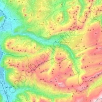
Name: Muotathal topographic map, elevation, terrain.
Location: Muotathal, Schwyz, 6436, Schweiz (46.88529 8.66729 47.02694 8.97164)
Average elevation: 1,439 m
Minimum elevation: 430 m
Maximum elevation: 2,960 m
Die Gemeinde liegt auf einer Höhe von 610 m ü. M. und bildet den südöstlichen Teil des Kantons Schwyz, grenzt im Süden an den Kanton Uri und im Osten an den Kanton Glarus. Mit 172 km² zählt Muotathal zu den zehn flächenmässig grössten Gemeinden der Schweiz und ist fast so gross wie der Kanton Appenzell Innerrhoden. Muotathal besteht aus den Ortschaften Muotathal, Hinterthal, Bisisthal und Ried.
Other topographic maps
Click on a map to view its topography, its elevation and its terrain.
Unterschönenbuch
Schweiz > Schwyz > Schwyz > Ingenbohl
Unterschönenbuch, Ingenbohl, Schwyz, 6438, Schweiz
Average elevation: 615 m
Hüseren
Schweiz > Schwyz > Schwyz > Riemenstalden
Hüseren, Riemenstalden, Schwyz, 6452, Schweiz
Average elevation: 1,334 m