
Morschach topographic map
Interactive map
Click on the map to display elevation.
About this map
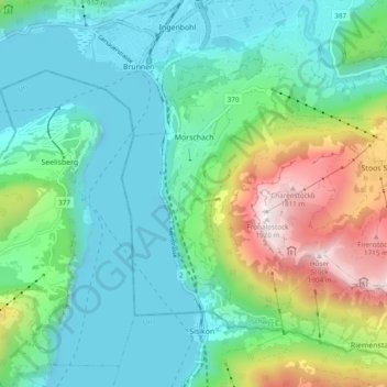
Name: Morschach topographic map, elevation, terrain.
Location: Morschach, Schwyz, Schweiz (46.94962 8.60118 46.99552 8.69712)
Average elevation: 797 m
Minimum elevation: 414 m
Maximum elevation: 1,913 m
Von Brunnen führt eine zweispurige Nebenstrasse hoch nach Morschach. Sie wird von der Buslinie Nr. 4 Auto AG Schwyz befahren. Von Morschach aus gelangt man per Luftseilbahn Morschach–Stoos zum noch höher gelegenen Skiort Stoos und von dort auf den Fronalpstock (1922 m ü. M.) oder zu Fuss auf dem Weg der Schweiz nach dem Urner Dorf Sisikon. Von Axenstein führen zwei Fusspfade nach Brunnen (Wanderung ca. 40 Minuten).
Other topographic maps
Click on a map to view its topography, its elevation and its terrain.
Unterschönenbuch
Schweiz > Schwyz > Schwyz > Ingenbohl
Unterschönenbuch, Ingenbohl, Schwyz, 6438, Schweiz
Average elevation: 615 m
Hüseren
Schweiz > Schwyz > Schwyz > Riemenstalden
Hüseren, Riemenstalden, Schwyz, 6452, Schweiz
Average elevation: 1,334 m