Geolocate

Hastings District topographic map

Interactive map

Click on the map to display elevation.

About this map

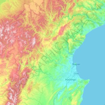
Name: Hastings District topographic map, elevation, terrain.

Location: Hastings District, Hawke's Bay, New Zealand (-39.89263 176.14273 -38.85596 177.09602)

Average elevation: 466 m

Minimum elevation: 0 m

Maximum elevation: 1,720 m

Other topographic maps

Click on a map to view its topography, its elevation and its terrain.

Flaxmere

New Zealand > Hawke's Bay > Hastings District

Average elevation: 20 m

Bluff Hill

New Zealand > Hawke's Bay > Napier

Average elevation: 14 m

Hastings

New Zealand > Hawke's Bay > Hastings District

Average elevation: 68 m

Tuai

New Zealand > Hawke's Bay > Wairoa District

Average elevation: 378 m

Hastings

New Zealand > Hawke's Bay > Hastings District

Average elevation: 68 m

Te Haroto

New Zealand > Hawke's Bay > Hastings District

Average elevation: 647 m

Briens

New Zealand > Hawke's Bay > Hastings District

Average elevation: 592 m

Omahu

New Zealand > Hawke's Bay > Hastings District

Average elevation: 31 m

Kokako

New Zealand > Hawke's Bay > Wairoa District > Tuai

Average elevation: 381 m

Tutira

New Zealand > Hawke's Bay > Hastings District

Average elevation: 191 m

Hastings

New Zealand > Hawke's Bay > Hastings District

Average elevation: 68 m

Sherenden

New Zealand > Hawke's Bay > Hastings District

Average elevation: 258 m

Hastings

New Zealand > Hawke's Bay > Hastings District

Average elevation: 68 m