
Hobart topographic map
Interactive map
Click on the map to display elevation.
About this map
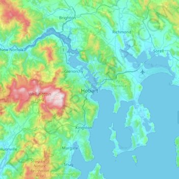
Name: Hobart topographic map, elevation, terrain.
Location: Hobart, City of Hobart, Tasmania, Australia (-43.10362 147.09169 -42.65538 147.64559)
Average elevation: 179 m
Minimum elevation: -2 m
Maximum elevation: 1,260 m
Although Hobart itself rarely receives snow during the winter due to the foehn effect created by the Central Highlands (the city's geographic position causes a rainshadow), the adjacent Kunanyi/Mount Wellington is frequently seen with a snowcap throughout the year including in summer. During the 20th century, the city itself has received snowfalls at sea level on average only once every 5 years; however, outer suburbs lying higher on the slopes of Mount Wellington receive snow more often, owing to the more exposed position coupled with them resting at higher altitude. These snow-bearing winds often carry on through Tasmania and Victoria to the Snowy Mountains in Victoria and southern New South Wales.
Other topographic maps
Click on a map to view its topography, its elevation and its terrain.
Jackeys Marsh
Jackeys Marsh, Meander Valley, Tasmania, 7304, Australia
Average elevation: 760 m
Goulds Country
Goulds Country, Break O'Day, Tasmania, 7216, Australia
Average elevation: 308 m
Lake Belton
Lake Belton, Derwent Valley, Tasmania, Australia
Average elevation: 1,056 m
Vale of Belvoir Conservation Area
Vale of Belvoir Conservation Area, Kentish, Tasmania, Australia
Average elevation: 866 m
Erith Island
Erith Island, Flinders Council, Tasmania, Australia
Average elevation: 23 m
Chicken Island
Chicken Island, Huon Valley, Tasmania, Australia
Average elevation: 4 m
Mount Nelson
Mount Nelson, Hobart, City of Hobart, Tasmania, 7007, Australia
Average elevation: 198 m
West Hobart
West Hobart, Hobart, City of Hobart, Tasmania, 7000, Australia
Average elevation: 105 m
Lake Pedder
Australia > Tasmania > Strathgordon
Lake Pedder, Strathgordon, Derwent Valley, Tasmania, Australia
Average elevation: 366 m
Mersey Forest
Mersey Forest, Meander Valley, Tasmania, Australia
Average elevation: 866 m
Launceston
Launceston, City of Launceston, Tasmania, Australia
Average elevation: 194 m
Port Arthur
Port Arthur, Tasman, Tasmania, 7182, Australia
Average elevation: 153 m
Highland Waters
Australia > Tasmania > London Lakes
Highland Waters, London Lakes, Central Highlands, Tasmania, Australia
Average elevation: 759 m
Flinders Island
Flinders Island, Tasmania, 7255, Australia
Average elevation: 20 m
Bullock Hill
Bullock Hill, Grove, Huon Valley, Tasmania, Australia
Average elevation: 147 m
Grey Mares Tail
Australia > Tasmania > St Marys
Grey Mares Tail, St Marys, Break O'Day, Tasmania, Australia
Average elevation: 349 m
Anderson Island
Anderson Island, Flinders Council, Tasmania, Australia
Average elevation: 4 m
Macquarie Island
Macquarie Island, Huon Valley, Tasmania, Australia
Average elevation: 20 m
Bruny Island
Australia > Tasmania > Alonnah
Bruny Island, Alonnah, Kingborough, Tasmania, Australia
Average elevation: 59 m