
Make a donation
Gear up for your next adventure:
As an Amazon Associate, this site earns from qualifying purchases at no extra cost to you.
Wellow topographic map
Click on the map to display elevation.
Make a donation
Gear up for your next adventure:
As an Amazon Associate, this site earns from qualifying purchases at no extra cost to you.
About this map
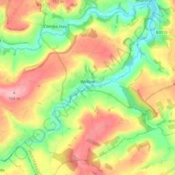
Name: Wellow topographic map, elevation, terrain.
Average elevation: 99 m
Minimum elevation: 31 m
Maximum elevation: 170 m
Bath and North East Somerset trails, hiking, mountain biking, running and outdoor activities
Make a donation
Gear up for your next adventure:
As an Amazon Associate, this site earns from qualifying purchases at no extra cost to you.
Other topographic maps
Click on a map to view its topography, its elevation and its terrain.
Hallatrow
United Kingdom > England > Bath and North East Somerset > High Littleton
Average elevation: 119 m
Norton Hawkfield
United Kingdom > England > Bath and North East Somerset > Norton Malreward
Average elevation: 96 m
Make a donation
Gear up for your next adventure:
As an Amazon Associate, this site earns from qualifying purchases at no extra cost to you.
Knowle Hill
United Kingdom > England > Bath and North East Somerset > Chew Magna
Average elevation: 65 m
Little Solsbury Hill
United Kingdom > England > Bath and North East Somerset > Batheaston
Average elevation: 88 m
Bathwick Hill
United Kingdom > England > Bath and North East Somerset > Bath
Number 1 (Bathwick Lodge) is a 2-storey villa with a steep Mansard room, built in 1825, extended in 1840 and the late C19. Probably by John Pinch the Elder.[4] Number 2 is from the early 19th century and has shutters over the windows.[11] Number 3 includes a porch which is elaborately enriched with carving,…
Average elevation: 93 m
North Wick
United Kingdom > England > Bath and North East Somerset > Chew Magna
Average elevation: 110 m
Make a donation
Gear up for your next adventure:
As an Amazon Associate, this site earns from qualifying purchases at no extra cost to you.
Carlingcott
United Kingdom > England > Bath and North East Somerset > Peasedown St. John
Average elevation: 123 m
Pipehouse
United Kingdom > England > Bath and North East Somerset > Hinton Charterhouse
Average elevation: 94 m
Make a donation
Gear up for your next adventure:
As an Amazon Associate, this site earns from qualifying purchases at no extra cost to you.
Keynsham Memorial Park
United Kingdom > England > Bath and North East Somerset > Keynsham
Average elevation: 29 m
Stoney Littleton
United Kingdom > England > Bath and North East Somerset > Shoscombe
Average elevation: 116 m
Make a donation
Gear up for your next adventure:
As an Amazon Associate, this site earns from qualifying purchases at no extra cost to you.
Clutton Hill
United Kingdom > England > Bath and North East Somerset > Farmborough
Average elevation: 133 m
Make a donation
Gear up for your next adventure:
As an Amazon Associate, this site earns from qualifying purchases at no extra cost to you.
Sharpstone
United Kingdom > England > Bath and North East Somerset > Freshford
Average elevation: 93 m
Monger
United Kingdom > England > Bath and North East Somerset > Midsomer Norton
Average elevation: 118 m
Make a donation
Gear up for your next adventure:
As an Amazon Associate, this site earns from qualifying purchases at no extra cost to you.
Park Corner
United Kingdom > England > Bath and North East Somerset > Freshford > Park Corner
Average elevation: 93 m
Maes Knoll
United Kingdom > England > Bath and North East Somerset > Norton Malreward
Average elevation: 110 m
Wick Green
United Kingdom > England > Bath and North East Somerset > Bishop Sutton
Average elevation: 82 m
Make a donation
Gear up for your next adventure:
As an Amazon Associate, this site earns from qualifying purchases at no extra cost to you.
Whitley Batts
United Kingdom > England > Bath and North East Somerset > Pensford
Average elevation: 87 m
Chewton Keynsham
United Kingdom > England > Bath and North East Somerset > Compton Dando
Average elevation: 57 m
Make a donation
Gear up for your next adventure:
As an Amazon Associate, this site earns from qualifying purchases at no extra cost to you.