
Castleknock topographic map
Interactive map
Click on the map to display elevation.
About this map
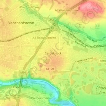
Name: Castleknock topographic map, elevation, terrain.
Location: Castleknock, Fingal, Dublin 15, Leinster, D15 VY32, Irland (53.35296 -6.38247 53.39296 -6.34247)
Average elevation: 55 m
Minimum elevation: 7 m
Maximum elevation: 98 m
Other topographic maps
Click on a map to view its topography, its elevation and its terrain.
Lower Lough Bray
Lower Lough Bray, Powerscourt ED, The Municipal District of Bray, County Wicklow, Leinster, Irland
Average elevation: 455 m
Eagle's Crag
Eagle's Crag, Powerscourt ED, The Municipal District of Bray, County Wicklow, Leinster, Irland
Average elevation: 490 m
The Municipal District of Wicklow
The Municipal District of Wicklow, County Wicklow, Leinster, Irland
Average elevation: 263 m
Glencullen ED
Glencullen ED, Dublin 18, Dún Laoghaire-Rathdown, County Dublin, Leinster, Irland
Average elevation: 137 m
Dingle - Daingean Uí Chúis
Irland > Dingle - Daingean Uí Chúis
Dingle - Daingean Uí Chúis, County Kerry, Munster, Irland
Average elevation: 77 m
Attimonmore South
Attimonmore South, Cloonkeen ED, Athenry-Oranmore Municipal District, County Galway, Connacht, Irland
Average elevation: 75 m
North Bull Island
North Bull Island, Raheny St. Assam ED, Dublin 5, Dublin, County Dublin, Leinster, Irland
Average elevation: 2 m
Valentia Island
Valentia Island, Kenmare Municipal District, County Kerry, Munster, Irland
Average elevation: 39 m