
Make a donation
Gear up for your next adventure:
As an Amazon Associate, this site earns from qualifying purchases at no extra cost to you.
Loures topographic map
Click on the map to display elevation.
Make a donation
Gear up for your next adventure:
As an Amazon Associate, this site earns from qualifying purchases at no extra cost to you.
About this map
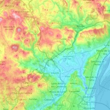
Name: Loures topographic map, elevation, terrain.
Location: Loures, Lisbon, Portugal (38.77481 -9.24600 38.94091 -9.06876)
Average elevation: 158 m
Minimum elevation: -2 m
Maximum elevation: 429 m
Make a donation
Gear up for your next adventure:
As an Amazon Associate, this site earns from qualifying purchases at no extra cost to you.
Other topographic maps
Click on a map to view its topography, its elevation and its terrain.
Make a donation
Gear up for your next adventure:
As an Amazon Associate, this site earns from qualifying purchases at no extra cost to you.
Make a donation
Gear up for your next adventure:
As an Amazon Associate, this site earns from qualifying purchases at no extra cost to you.
Make a donation
Gear up for your next adventure:
As an Amazon Associate, this site earns from qualifying purchases at no extra cost to you.
Make a donation
Gear up for your next adventure:
As an Amazon Associate, this site earns from qualifying purchases at no extra cost to you.
Sintra
Portugal > Lisbon > Sintra (Santa Maria e São Miguel, São Martinho e São Pedro de Penaferrim)
The São João platform, along the northern flank of the Sintra Mountains, has altitudes between 100 metres (110 yd) and 150 metres (160 yd), while the southern part of the mountains, the Cascais platform, is lower: sloping from 150 metres (160 yd) to the sea, terminating along the coast, around 30 metres (33…
Average elevation: 189 m
Make a donation
Gear up for your next adventure:
As an Amazon Associate, this site earns from qualifying purchases at no extra cost to you.
Beloura
Portugal > Lisbon > Sintra (Santa Maria e São Miguel, São Martinho e São Pedro de Penaferrim)
Average elevation: 182 m
Make a donation
Gear up for your next adventure:
As an Amazon Associate, this site earns from qualifying purchases at no extra cost to you.
Make a donation
Gear up for your next adventure:
As an Amazon Associate, this site earns from qualifying purchases at no extra cost to you.
Make a donation
Gear up for your next adventure:
As an Amazon Associate, this site earns from qualifying purchases at no extra cost to you.
Make a donation
Gear up for your next adventure:
As an Amazon Associate, this site earns from qualifying purchases at no extra cost to you.
Make a donation
Gear up for your next adventure:
As an Amazon Associate, this site earns from qualifying purchases at no extra cost to you.
Make a donation
Gear up for your next adventure:
As an Amazon Associate, this site earns from qualifying purchases at no extra cost to you.
Almornos
Portugal > Lisbon > Almargem do Bispo, Pêro Pinheiro e Montelavar > Aruil de Baixo
Average elevation: 260 m
Make a donation
Gear up for your next adventure:
As an Amazon Associate, this site earns from qualifying purchases at no extra cost to you.
Make a donation
Gear up for your next adventure:
As an Amazon Associate, this site earns from qualifying purchases at no extra cost to you.
Negrais
Portugal > Lisbon > Sintra > Almargem do Bispo, Pêro Pinheiro e Montelavar
Average elevation: 214 m
Alfouvar de Cima
Portugal > Lisbon > Sintra > Almargem do Bispo, Pêro Pinheiro e Montelavar
Average elevation: 193 m
Make a donation
Gear up for your next adventure:
As an Amazon Associate, this site earns from qualifying purchases at no extra cost to you.
Moita dos Ferreiros
Portugal > Lisbon > Moita dos Ferreiros > Moita dos Ferreiros
Average elevation: 100 m
Make a donation
Gear up for your next adventure:
As an Amazon Associate, this site earns from qualifying purchases at no extra cost to you.
Rio Lizandro
Portugal > Lisbon > São João das Lampas e Terrugem > Terrugem > Armés
Average elevation: 128 m