
Ghingartola topographic map
Interactive map
Click on the map to display elevation.
About this map
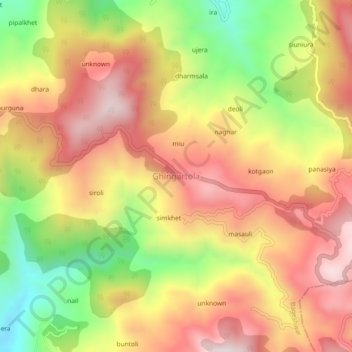
Name: Ghingartola topographic map, elevation, terrain.
Location: Ghingartola, Bageshwar, Uttarakhand, 263619, India (29.81337 79.82864 29.85337 79.86864)
Average elevation: 1,478 m
Minimum elevation: 1,092 m
Maximum elevation: 1,782 m
Other topographic maps
Click on a map to view its topography, its elevation and its terrain.
dharmsala
India > Uttarakhand > Bageshwar > Ghingartola
dharmsala, Ghingartola, Bageshwar, Uttarakhand, 263619, India
Average elevation: 1,429 m
mankot
India > Uttarakhand > Bageshwar > Bāgeshwar
mankot, Bāgeshwar, Bageshwar, Uttarakhand, 263642, India
Average elevation: 1,305 m
Nandigaon
India > Uttarakhand > Bageshwar > Nandigaon
Nandigaon, Bageshwar, Uttarakhand, India
Average elevation: 1,375 m