
Kedamean topographic map
Interactive map
Click on the map to display elevation.
About this map
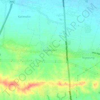
Name: Kedamean topographic map, elevation, terrain.
Location: Kedamean, Gresik, East Java, Java, Indonesia (-7.34518 112.53944 -7.30518 112.57944)
Average elevation: 29 m
Minimum elevation: 11 m
Maximum elevation: 66 m
Other topographic maps
Click on a map to view its topography, its elevation and its terrain.
Gunung Limas
Indonesia > East Java > Gresik
Gunung Limas, Gresik, East Java, Indonesia
Average elevation: 64 m
Sembungan Kidul
Indonesia > East Java > Gresik > Sembungan Kidul
Sembungan Kidul, Gresik, East Java, 61152, Indonesia
Average elevation: 7 m