
Oddar Meanchey topographic map
Interactive map
Click on the map to display elevation.
About this map
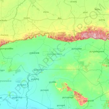
Name: Oddar Meanchey topographic map, elevation, terrain.
Location: Oddar Meanchey, Cambodia (13.87691 103.03187 14.44037 104.50858)
Average elevation: 113 m
Minimum elevation: 7 m
Maximum elevation: 670 m
Other topographic maps
Click on a map to view its topography, its elevation and its terrain.