
Make a donation
Gear up for your next adventure:
As an Amazon Associate, this site earns from qualifying purchases at no extra cost to you.
Al Mazra'a topographic map
Click on the map to display elevation.
Make a donation
Gear up for your next adventure:
As an Amazon Associate, this site earns from qualifying purchases at no extra cost to you.
About this map
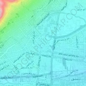
Name: Al Mazra'a topographic map, elevation, terrain.
Location: Al Mazra'a, Salhiyeh, Damascus Governorate, Syria (33.51996 36.29086 33.52843 36.30184)
Average elevation: 720 m
Minimum elevation: 676 m
Maximum elevation: 1,006 m
Make a donation
Gear up for your next adventure:
As an Amazon Associate, this site earns from qualifying purchases at no extra cost to you.
Other topographic maps
Click on a map to view its topography, its elevation and its terrain.
Barada River
Syria > Damascus Governorate > Damascus Subdistrict > Al-Qanawat Municipality
Average elevation: 703 m
Make a donation
Gear up for your next adventure:
As an Amazon Associate, this site earns from qualifying purchases at no extra cost to you.
Tishreen Park
Syria > Damascus Governorate > Damascus Subdistrict > Al-Muhajerin Municipality
Average elevation: 771 m
Jabal Qasiyun
Syria > Damascus Governorate > Damascus Subdistrict > Dummar Municipality
The mountain is also host to an endemic species of iris, Iris damascena, which can be found on the steep eastern slopes, at high elevation. The Syrian government has not given the species any protected status but part of the habitat of the species lies within a military area near the Qassioun Republican Guards…
Average elevation: 946 m
Qaboun
Syria > Damascus Governorate > Damascus Subdistrict > Al-Qaboun Municipality
Average elevation: 748 m
Make a donation
Gear up for your next adventure:
As an Amazon Associate, this site earns from qualifying purchases at no extra cost to you.
Sarouja
Syria > Damascus Governorate > Damascus Subdistrict > Sarouja Municipality
Average elevation: 749 m
Al Mazzeh
Syria > Damascus Governorate > Damascus Subdistrict > Al-Mazza Municipality
Average elevation: 790 m
Make a donation
Gear up for your next adventure:
As an Amazon Associate, this site earns from qualifying purchases at no extra cost to you.
Dummar
Syria > Damascus Governorate > Damascus Subdistrict > Dummar Municipality
Average elevation: 864 m