
Lower Himalayan Range topographic map
Interactive map
Click on the map to display elevation.
About this map
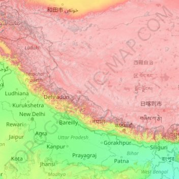
Name: Lower Himalayan Range topographic map, elevation, terrain.
Location: Lower Himalayan Range, Nepal (27.68355 76.04732 33.94340 91.88963)
Average elevation: 2,953 m
Minimum elevation: 2 m
Maximum elevation: 8,096 m
Other topographic maps
Click on a map to view its topography, its elevation and its terrain.
Mount Everest
Nepal > Eastern Development Region > Qutang > Khumjung
Mount Everest (Chinese: 珠穆朗玛 Zhūmùlǎngmǎ; Nepali: सगरमाथा, romanized: Sagarmāthā; Tibetan: Chomolungma ཇོ་མོ་གླང་མ) is Earth's highest mountain above sea level, located in the Mahalangur Himal sub-range of the Himalayas. The China–Nepal border runs across its…
Average elevation: 7,841 m
Pokhara
Pokhara is in the northwestern corner of the Pokhara Valley, which is a widening of the Seti Gandaki valley that lies in the region (Pahad) of the Himalayas. In this region the mountains rise very quickly, and within 30 kilometres (19 miles), the elevation rises from 1,000 to 7,500 metres (3,300 to 24,600…
Average elevation: 1,222 m
Machapuchare
Nepal > Gandaki Province > Kaski
Due to its southern position in the range and the particularly low terrain that lies south of the Annapurna Himalayas, which contains three of the 10 highest peaks in the world, Machapuchare commands tremendous vertical relief in a short horizontal distance. This, combined with its steep, pointed profile,…
Average elevation: 5,746 m
Kathmandu
Kathmandu, officially Kathmandu Metropolitan City, is the capital and most populous city of Nepal with 845,767 inhabitants living in 105,649 households in 2021 and 2.9 million people in its urban agglomeration. It is located in the Kathmandu Valley, a large valley in the high plateaus in central Nepal, at an…
Average elevation: 1,335 m
Dang
The Dudhwas rise steeply to a crest at about 700 meters, then slope more gradually into the Deukhuri Valley, down to 250 meters elevation at the Rapti River. The Dudhwas extend more than 100 km, causing the Rapti to detour west around them before turning southeast down the main trend of the plains into India.…
Average elevation: 746 m
Mount Everest
Nepal > Koshi Province > Solukhumbu
Mount Everest (Nepali: सगरमाथा, romanized: Sagarmāthā; Tibetan: Chomolungma ཇོ་མོ་གླང་མ; Chinese: 珠穆朗玛峰; pinyin: Zhūmùlǎngmǎ Fēng) is Earth's highest mountain above sea level, located in the Mahalangur Himal sub-range of the Himalayas. The China–Nepal…
Average elevation: 7,850 m
Kala Patthar
Nepal > Koshi Province > Solukhumbu
The views of Everest, Nuptse and Changtse are spectacular from Kala Patthar and there are glimpses of the northern flank and summit of Lhotse. The world's highest webcam, Mount Everest webcam, was located here. Kala Patthar is considered the highest altitude most will reach without a climbing permit, which…
Average elevation: 5,434 m
Malangawa
Nepal > Madhesh Province > Sarlahi
Malangwa (Devanagari: मलंगवा) is a town, a municipality, and the headquarter of Sarlahi District in Madhesh Province of Nepal. The district's oldest municipality, it is in parliamentary constituency 2. From the Mahendra Highway 25 kilometres (16 mi) south of Nawalpur, a small highway side town.…
Average elevation: 83 m
Tengboche
Nepal > Koshi Province > Solukhumbu
Tengboche is located on a hill at the confluence of the Dudh Kosi and the Imja Khola rivers. It lies in Solukhumbu district to the north east of Kathmandu on the Nepal – Tibet border. It is inhabited by sherpas ('sherpa' literally means the easterner) who migrated from Tibet six hundred years ago. It is…
Average elevation: 3,936 m
Ilam
Nepal > Koshi Province > Ilam
The word ‘Ilam’ comprises two words-‘I’ and ‘Lam’. In Limbu language, the word ‘I’ means ‘winding’ and ‘lam’ denotes the way. The topography of this Ilam aptly depicts several winding paths crisscrossing.
Average elevation: 919 m
Gokyo
Nepal > Koshi Province > Solukhumbu
The village is located at an elevation of 4,750 m (15,584 ft), making it one of the highest settlements in Nepal and in the world. Almost all the buildings are guest houses for trekkers. The people who live in the village leave during the winter and move to other (lower) villages such as Namche Bazaar.
Average elevation: 4,919 m