Geolocate

Licking River topographic map

Interactive map

Click on the map to display elevation.

Licking River

The Licking River rises in the Cumberland Plateau of eastern Kentucky, in southeastern Magoffin County (37°31'16"N 82°55'56"W) at the confluence of two smaller streams and an elevation of 1006 feet. It flows northwest in a highly meandering course past Salyersville and West Liberty. In Rowan County in the Daniel Boone National Forest it is impounded to form the large Cave Run Lake reservoir. Northwest of the reservoir it receives Fleming Creek approximately 8 miles (13 km) northwest of Carlisle and flows across the Bluegrass region of northern Kentucky. It receives the North Fork Licking River from the east approximately 10 miles (16 km) northwest of Mount Olivet and the South Fork Licking River from the south at Falmouth. It joins the Ohio opposite Cincinnati, where it separates the cities of Covington and Newport. The river was used as the southwestern border of the original Mason County and is the southwest border of Fleming and Rowan counties today.

Wikipedia (CC-BY-SA 3.0)

About this map

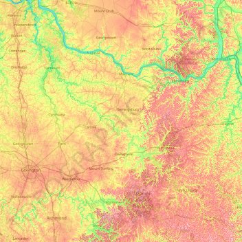
Name: Licking River topographic map, elevation, terrain.

Location: Licking River, Kentucky, United States (37.59851 -84.50492 39.09370 -82.95702)

Average elevation: 269 m

Minimum elevation: 142 m

Maximum elevation: 453 m

Other topographic maps

Click on a map to view its topography, its elevation and its terrain.

Lexington

United States > Kentucky > Lexington

Average elevation: 285 m

Christian County

United States > Kentucky

Average elevation: 171 m

New Concord

United States > Kentucky > Calloway County

Average elevation: 125 m

Haw Hill

United States > Kentucky > Livingston County

Average elevation: 117 m

Campbell County

United States > Kentucky

Average elevation: 223 m

Adair County

United States > Kentucky

Average elevation: 258 m

Owingsville

United States > Kentucky > Bath County

Average elevation: 262 m

Ballard County

United States > Kentucky

Average elevation: 113 m

Silerville

United States > Kentucky > McCreary County

Average elevation: 407 m

Highway

United States > Kentucky > Clinton County

Average elevation: 287 m

Okolona

United States > Kentucky > Jefferson County > Louisville

Average elevation: 147 m

Walton

United States > Kentucky > Boone County

Average elevation: 264 m

Nancy

United States > Kentucky > Pulaski County

Average elevation: 312 m

Crittenden County

United States > Kentucky

Average elevation: 141 m

Richmond

United States > Kentucky > Madison County

Average elevation: 281 m

Gamaliel

United States > Kentucky > Monroe County

Average elevation: 233 m

Island

United States > Kentucky > McLean County

Average elevation: 129 m

Paris

United States > Kentucky > Bourbon County

Average elevation: 265 m

Russell

United States > Kentucky > Greenup County

Average elevation: 192 m

Druid Hills

United States > Kentucky > Jefferson County

Average elevation: 169 m

Garrard County

United States > Kentucky

Average elevation: 279 m

Lily

United States > Kentucky > Laurel County

Average elevation: 350 m

London

United States > Kentucky > Laurel County

Average elevation: 370 m

Keavy

United States > Kentucky > Laurel County

Average elevation: 363 m

Floyd County

United States > Kentucky

Average elevation: 353 m

Crow Hollow

United States > Kentucky > Pike County > Douglas

Average elevation: 348 m

Lee City

United States > Kentucky > Wolfe County

Average elevation: 336 m

Straw

United States > Kentucky > Edmonson County

Average elevation: 225 m

Loretto

United States > Kentucky > Marion County

Average elevation: 222 m

Grant County

United States > Kentucky

Average elevation: 243 m

The Moors

United States > Kentucky > Marshall County

Average elevation: 114 m

Mammoth Cave

United States > Kentucky > Edmonson County

Average elevation: 207 m

Logan County

United States > Kentucky

Average elevation: 187 m

Elizabethtown

United States > Kentucky > Hardin County

Average elevation: 241 m

Harrison County

United States > Kentucky

Average elevation: 249 m

Whittle

United States > Kentucky > Russell County

Average elevation: 297 m

Annville

United States > Kentucky > Jackson County

Average elevation: 359 m

Daviess County

United States > Kentucky

Average elevation: 130 m

Ready

United States > Kentucky > Grayson County

Average elevation: 206 m

Salvisa

United States > Kentucky > Mercer County

Average elevation: 248 m

Waddy

United States > Kentucky > Shelby County

Average elevation: 260 m

Woodbury

United States > Kentucky > Butler County

Average elevation: 134 m

Winburn

United States > Kentucky > Fayette County > Lexington

Average elevation: 292 m

Ludlow

United States > Kentucky > Kenton County

Average elevation: 182 m