
Yakoruda topographic map
Interactive map
Click on the map to display elevation.
About this map
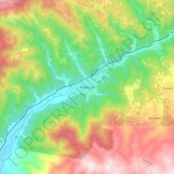
Name: Yakoruda topographic map, elevation, terrain.
Location: Yakoruda, Blagoevgrad, 2790, Bulgaria (41.97729 23.62778 42.05729 23.70778)
Average elevation: 1,191 m
Minimum elevation: 825 m
Maximum elevation: 1,681 m
Other topographic maps
Click on a map to view its topography, its elevation and its terrain.
Laki
In 1889, Stefan Verkovic (Topographical and Ethnographic Essay of Macedonia) noted Lika (Laki) as a village with 63 Bulgarian and 18 Turkish houses.
Average elevation: 805 m
Bansko
Bansko (Bulgarian: Банско [ˈbansko]) is a town in southwestern Bulgaria, located at the foot of the Pirin Mountains at an elevation of 1200m above sea level. It is a ski resort.
Average elevation: 1,034 m
Tuhovishta
Tuhovishta Village is located in the southwestern Rhodope Mountains and is part of the historical and geographical area Chech. t is located about 2 kilometers from the border with Greece. Altitude of the village is 700–999 meters and the area of the land is 17.15 km2. The village adjoins the lands of the…
Average elevation: 765 m