
Алантепе topographic map
Interactive map
Click on the map to display elevation.
About this map
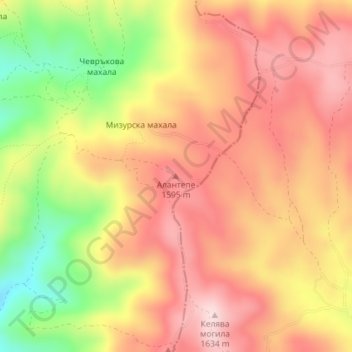
Name: Алантепе topographic map, elevation, terrain.
Location: Алантепе, Belitsa, Blagoevgrad, 2785, Bulgaria (41.95181 23.76101 41.95191 23.76111)
Average elevation: 1,512 m
Minimum elevation: 1,332 m
Maximum elevation: 1,629 m
Other topographic maps
Click on a map to view its topography, its elevation and its terrain.
Laki
In 1889, Stefan Verkovic (Topographical and Ethnographic Essay of Macedonia) noted Lika (Laki) as a village with 63 Bulgarian and 18 Turkish houses.
Average elevation: 805 m
Bansko
Bansko (Bulgarian: Банско [ˈbansko]) is a town in southwestern Bulgaria, located at the foot of the Pirin Mountains at an elevation of 1200m above sea level. It is a ski resort.
Average elevation: 1,034 m
Tuhovishta
Tuhovishta Village is located in the southwestern Rhodope Mountains and is part of the historical and geographical area Chech. t is located about 2 kilometers from the border with Greece. Altitude of the village is 700–999 meters and the area of the land is 17.15 km2. The village adjoins the lands of the…
Average elevation: 765 m
Sandanski
Sandanski has developed in an amphitheatrical fashion on the outer south-west flanks of Pirin Mountains along the lower reaches of Sandanska Bistritsa River. The town's altitude varies between 240 and 300 meters. Its geographical location between Kresna and Rupel Gorges determines town's mild winter…
Average elevation: 276 m