
la Torre de Fontaubella topographic map
Interactive map
Click on the map to display elevation.
About this map
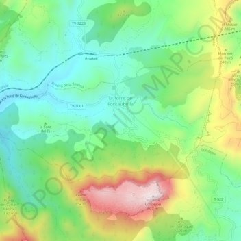
Name: la Torre de Fontaubella topographic map, elevation, terrain.
Average elevation: 516 m
Minimum elevation: 297 m
Maximum elevation: 920 m
Other topographic maps
Click on a map to view its topography, its elevation and its terrain.
Pradell de la Teixeta
Pradell de la Teixeta, Priorat, Tarragone, Catalogne, 43774, Espagne
Average elevation: 491 m
els Guiamets
els Guiamets, Priorat, Tarragone, Catalogne, 43777, Espagne
Average elevation: 205 m