
Make a donation
Gear up for your next adventure:
As an Amazon Associate, this site earns from qualifying purchases at no extra cost to you.
Parsa topographic map
Click on the map to display elevation.
Make a donation
Gear up for your next adventure:
As an Amazon Associate, this site earns from qualifying purchases at no extra cost to you.
About this map
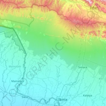
Name: Parsa topographic map, elevation, terrain.
Location: Parsa, Madhesh Province, Nepal (26.98394 84.48380 27.46375 84.97376)
Average elevation: 234 m
Minimum elevation: 74 m
Maximum elevation: 1,004 m
Make a donation
Gear up for your next adventure:
As an Amazon Associate, this site earns from qualifying purchases at no extra cost to you.
Other topographic maps
Click on a map to view its topography, its elevation and its terrain.
Make a donation
Gear up for your next adventure:
As an Amazon Associate, this site earns from qualifying purchases at no extra cost to you.
Make a donation
Gear up for your next adventure:
As an Amazon Associate, this site earns from qualifying purchases at no extra cost to you.
Birgunj
Nepal > Madhesh Province > Parsa
Birgunj is located in the Terai plain which is the northern part of the Indo-Gangetic plain. Birgunj metropolitan city has an elongated shape. The variation in altitude is in the range of 78 m to 95 m when moving from south to north of Birgunj. Although the range of altitude variation is small, but there is a…
Average elevation: 88 m