
Caln Township topographic map
Interactive map
Click on the map to display elevation.
About this map
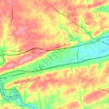
Name: Caln Township topographic map, elevation, terrain.
Location: Caln Township, Chester County, Pennsylvania, United States (39.98129 -75.81424 40.02122 -75.70405)
Average elevation: 145 m
Minimum elevation: 70 m
Maximum elevation: 204 m
Other topographic maps
Click on a map to view its topography, its elevation and its terrain.
Ship Road
United States > Pennsylvania > Chester County > West Whiteland Township > Exton
Average elevation: 133 m
Thorndale
United States > Pennsylvania > Chester County > Caln Township > Thorndale
Average elevation: 116 m
Grove
United States > Pennsylvania > Chester County > West Whiteland Township
Average elevation: 128 m
Martins Corner
United States > Pennsylvania > Chester County > West Caln Township
Average elevation: 212 m
Nottingham
United States > Pennsylvania > Chester County > West Nottingham Township > Nottingham
Average elevation: 145 m
Paoli
United States > Pennsylvania > Chester County > Tredyffrin Township > Paoli
Average elevation: 128 m
French Creek State Park
United States > Pennsylvania > Chester County > Warwick Township
Average elevation: 148 m
Exton
United States > Pennsylvania > Chester County > West Whiteland Township > Exton
Average elevation: 118 m
Chesterbrook
United States > Pennsylvania > Chester County > Tredyffrin Township
Average elevation: 70 m
Exton
United States > Pennsylvania > Chester County > West Whiteland Township
Average elevation: 125 m
Chester Springs
United States > Pennsylvania > Chester County > West Pikeland Township
Average elevation: 112 m