
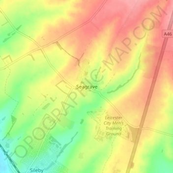
Seagrave topographic map
Interactive map
Click on the map to display elevation.
About this map
Name: Seagrave topographic map, elevation, terrain.
Average elevation: 92 m
Minimum elevation: 43 m
Maximum elevation: 132 m
Other topographic maps
Click on a map to view its topography, its elevation and its terrain.
Barkby Thorpe
United Kingdom > England > Leicestershire > Borough of Charnwood
Barkby Thorpe, Borough of Charnwood, Leicestershire, England, United Kingdom
Average elevation: 89 m
Mammoth Lake
United Kingdom > England > Leicestershire > Borough of Charnwood > Thurmaston
Mammoth Lake, Thurmaston, Borough of Charnwood, Leicestershire, England, United Kingdom
Average elevation: 58 m
Charnwood Forest Canal (Disused)
United Kingdom > England > Leicestershire > Borough of Charnwood > Nanpantan
Charnwood Forest Canal (Disused), Nanpantan, Borough of Charnwood, Leicestershire, England, LE11 3YA, United Kingdom
Average elevation: 98 m
Anstey
United Kingdom > England > Leicestershire > Borough of Charnwood
Anstey, Borough of Charnwood, Leicestershire, England, United Kingdom
Average elevation: 84 m
Wanlip
United Kingdom > England > Leicestershire > Borough of Charnwood
Wanlip, Borough of Charnwood, Leicestershire, England, LE7 4PH, United Kingdom
Average elevation: 61 m
Ratcliffe on the Wreake
United Kingdom > England > Leicestershire > Borough of Charnwood
Ratcliffe on the Wreake, Borough of Charnwood, Leicestershire, England, LE7 4SN, United Kingdom
Average elevation: 68 m
Thurcaston
United Kingdom > England > Leicestershire > Borough of Charnwood
Thurcaston, Borough of Charnwood, Leicestershire, England, LE7 7JP, United Kingdom
Average elevation: 73 m