
Make a donation
Gear up for your next adventure:
As an Amazon Associate, this site earns from qualifying purchases at no extra cost to you.
National Park Rila topographic map
Click on the map to display elevation.
Make a donation
Gear up for your next adventure:
As an Amazon Associate, this site earns from qualifying purchases at no extra cost to you.
About this map
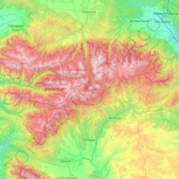
Name: National Park Rila topographic map, elevation, terrain.
Location: National Park Rila, Samokov, Sofia, Bulgaria (41.93485 23.15718 42.26988 23.88610)
Average elevation: 1,413 m
Minimum elevation: 443 m
Maximum elevation: 2,911 m
Make a donation
Gear up for your next adventure:
As an Amazon Associate, this site earns from qualifying purchases at no extra cost to you.
Other topographic maps
Click on a map to view its topography, its elevation and its terrain.
Borovets
Borovets (Bulgarian: Боровец [ˈbɔrovɛt͡s]), known as Chamkoria (Чамкория [ˈt͡ʃam koˈrijɐ]) until the middle of the 20th century, is a popular Bulgarian mountain resort situated in Sofia Province, on the northern slopes of Rila mountain, at an elevation of 1350 m.
Average elevation: 1,394 m
Rila mountain range
Rila (Bulgarian: Рила, pronounced [ˈriɫɐ]) is the highest mountain range of Bulgaria, the Balkan Peninsula, and Southeast Europe. It is situated in southwestern Bulgaria and forms part of the Rila–Rhodope Massif. The highest summit is Musala at an elevation of 2,925 m which makes Rila the sixth…
Average elevation: 2,525 m
Make a donation
Gear up for your next adventure:
As an Amazon Associate, this site earns from qualifying purchases at no extra cost to you.
Make a donation
Gear up for your next adventure:
As an Amazon Associate, this site earns from qualifying purchases at no extra cost to you.