
Make a donation
Gear up for your next adventure:
As an Amazon Associate, this site earns from qualifying purchases at no extra cost to you.
Dearborn Heights topographic map
Click on the map to display elevation.
Make a donation
Gear up for your next adventure:
As an Amazon Associate, this site earns from qualifying purchases at no extra cost to you.
About this map
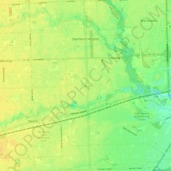
Name: Dearborn Heights topographic map, elevation, terrain.
Location: Dearborn Heights, Wayne County, Michigan, United States (42.26825 -83.31283 42.35706 -83.21769)
Average elevation: 190 m
Minimum elevation: 177 m
Maximum elevation: 197 m
Make a donation
Gear up for your next adventure:
As an Amazon Associate, this site earns from qualifying purchases at no extra cost to you.
Other topographic maps
Click on a map to view its topography, its elevation and its terrain.
Make a donation
Gear up for your next adventure:
As an Amazon Associate, this site earns from qualifying purchases at no extra cost to you.
Kresge Ford Basement Courtyard
United States > Michigan > Wayne County > Detroit
Average elevation: 193 m
Make a donation
Gear up for your next adventure:
As an Amazon Associate, this site earns from qualifying purchases at no extra cost to you.
Greenfield Village
United States > Michigan > Wayne County > Greenfield Village
Average elevation: 184 m