
Chatham Islands topographic map
Interactive map
Click on the map to display elevation.
About this map
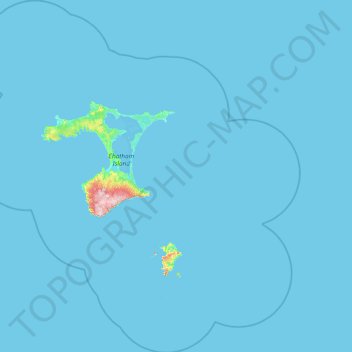
Name: Chatham Islands topographic map, elevation, terrain.
Location: Chatham Islands, New Zealand (-44.63499 -177.24469 -43.31080 -175.54142)
Average elevation: 3 m
Minimum elevation: 0 m
Maximum elevation: 291 m
Other topographic maps
Click on a map to view its topography, its elevation and its terrain.
Auckland
The Auckland Volcanic Field has contributed greatly to the growth and prosperity of the Auckland Region since the area was settled by humans. Initially, the maunga (scoria cones) were occupied and established as pā (fortified settlements) by Māori due to the strategic advantage their elevation provided in…
Average elevation: 32 m
Wellington
New Zealand > Wellington > Wellington City
Averaging 2,055 hours of sunshine per year, the climate of Wellington is temperate marine, (Köppen: Cfb), generally moderate all year round with warm summers and mild winters, and rarely sees temperatures above 23 °C (73 °F) or below 4 °C (39 °F). The hottest recorded temperature in the city is 31.1 °C…
Average elevation: 85 m
Dunedin
The climate of Dunedin in general is temperate. The city is recognised as having a large number of microclimates and the weather conditions often vary between suburbs mostly due to the city's topographical layout. Under the Köppen climate classification, Dunedin features an oceanic climate. The city's climate…
Average elevation: 110 m
Queenstown
New Zealand > Queenstown-Lakes District
The town is at a relatively low altitude for a ski and snowboarding centre, at 310 metres (1,020 ft) above sea level at the lake shore, but is nestled among mountains, most notably the scenic attraction of The Remarkables, to the town's southeast. Below the lake lies the deep Kawarau Gorge, and there are…
Average elevation: 592 m
Featherston
New Zealand > Wellington > South Wairarapa District > Featherston Community
Average elevation: 125 m
Hineteawa / Bowen Falls
New Zealand > Southland > Southland District > Fiordland Community
Average elevation: 232 m
Makarewa Junction
New Zealand > Southland > Southland District > Oreti Community
Average elevation: 17 m
Waimānu / Stirling Falls
New Zealand > Southland > Southland District > Fiordland Community
Average elevation: 423 m
Hanmer Springs
New Zealand > Hurunui District
The Jacks Pass – Clarence River – Jollies Pass Loop is a 25 kilometer loop which is not technically challenging however it takes between two to four hours to complete. It can be ridden in either direction: West over Jacks Pass (869m) or East over Jollies Pass (850m). As the entire ride is at high elevation…
Average elevation: 490 m
Mount Cook
New Zealand > Mackenzie District
Aoraki / Mount Cook is the highest mountain in New Zealand. Its height, as of 2014, is listed as 3,724 metres (12,218 feet). It is situated in the Southern Alps, the mountain range that runs the length of the South Island. A popular tourist destination, it is also a favourite challenge for mountaineers. Aoraki…
Average elevation: 2,920 m
Edendale
New Zealand > Southland > Southland District > Waihopai Toetoe Community
Average elevation: 41 m
Clifden
New Zealand > Southland > Southland District > Tuatapere Te Waewae Community
Average elevation: 70 m
Wellington
New Zealand > Wellington > Wellington City
Averaging 2,055 hours of sunshine per year, the climate of Wellington is temperate marine, (Köppen: Cfb, Trewartha: Cflk), generally moderate all year round with warm summers and cool to mild winters, and rarely sees temperatures above 26 °C (79 °F) or below 4 °C (39 °F). The hottest recorded temperature…
Average elevation: 85 m
Oban
New Zealand > Southland > Southland District > Stewart Island / Rakiura Community
Average elevation: 23 m