
Khulna Division topographic map
Interactive map
Click on the map to display elevation.
About this map
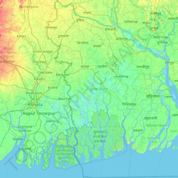
Name: Khulna Division topographic map, elevation, terrain.
Location: Khulna Division, Bangladesh (21.41004 88.55407 24.20678 89.99918)
Average elevation: 7 m
Minimum elevation: -3 m
Maximum elevation: 57 m
Other topographic maps
Click on a map to view its topography, its elevation and its terrain.
Dhaka
In 2013, suburban services to Narayanganj and Gazipur cities were upgraded using diesel electric multiple unit trains. The Dhaka Metro Rail feasibility study has been completed. A 20.1-kilometre (12.5 mi), $2.8-billion Phase 1 metro route is being negotiated by the Government with Japan International…
Average elevation: 7 m
Cox's Bazar
Bangladesh > Chattogram Division
Cox's Bazar lies on a coastal plain in the southeastern corner of Bangladesh. From above, the plain appears to bulge out into the Bay of Bengal. Along the shore is an extensive area of beach and dunes. Most of the city is built on a floodplain that is lower in elevation than the dunes, making it more…
Average elevation: 8 m
Chattogram
Bangladesh > Chattogram Division > Chattogram
Chittagong lies at 22°22′0″N 91°48′0″E / 22.36667°N 91.80000°E / 22.36667; 91.80000. It straddles the coastal foothills of the Chittagong Hill Tracts in southeastern Bangladesh. The Karnaphuli River runs along the southern banks of the city, including its central business district. The…
Average elevation: 6 m
Brahmaputra River
Bangladesh > Mymensingh Division > Jamalpur Sadar Upazila > Jamalpur
The course of the Brahmaputra River has changed drastically in the past two and a half centuries, moving its river course westwards for a distance of about 80 km (50 mi), leaving its old river course, appropriately named the old Brahmaputra river, behind. In the past, the floodplain of the old river course had…
Average elevation: 18 m
Mymensingh
Bangladesh > Mymensingh Division > Mymensingh Sadar Upazila
The city was constituted by the British East India Company on 1 May 1787. According to Ministry of Public Administration, Mymensingh is ranked 4th in district status. The population density of Mymensingh city is 44,458/km2 (115,150/sq mi), making it the second most densely populated city in Bangladesh.…
Average elevation: 14 m
Shahapur Play Ground
Bangladesh > Rangpur Division > Badarganj Upazila > Bodorganj
Average elevation: 34 m
Pond of Reshot Ali house
Bangladesh > Barishal Division > Borhanuddin Subdistrict
Average elevation: 5 m
Sylhet
Bangladesh > Sylhet Division > Sylhet Sadar Upazila
The name of Sylhet descended from Sanskrit word Srihatta (श्रीहट्ट / শ্রীহট্ট) which literally means elegant market. The name Sylhet is an anglicisation of Shilhot (শিলহট). Its origins seem to come from the Sanskrit according to the words of শিলা śilā…
Average elevation: 14 m
Tangail
Bangladesh > Dhaka Division > Tangail Sadar Upazila
The city of Tangail is in Dhaka Division, Central Bangladesh. The town lies in a low-lying floodplain near the Jamuna River, south of the high plateau of the Madhupur tract. The average elevation of Tangail is 14 meters (49 feet). Tangail experiences a Tropical savanna climate(Köppen: Aw ) with a hot, humid…
Average elevation: 11 m