
Make a donation
Gear up for your next adventure:
As an Amazon Associate, this site earns from qualifying purchases at no extra cost to you.
Shabelle topographic map
Click on the map to display elevation.
Make a donation
Gear up for your next adventure:
As an Amazon Associate, this site earns from qualifying purchases at no extra cost to you.
Shabelle
Grazing land for pastoralists make up the majority of Shabelle Zone. Six of its seven woredas are located along the banks of the Shebelle river, which flows out of the highlands through the Zone and into Somalia. 40-50% of the population depend on irrigated farming, 25-30% on agro-pastoralism and 20-30% on pastoralism and less than 1% on urban service activities. Shabelle is characterised by an "extensive flat to gently sloping topography" that accounts for about 94% of the Zone’s total area. An estimated 56% of the area of the zone is occupied by pasturage which consists of open grass land, bush and shrub grass land, and wooded grass land, while 33% is occupied by wood land, shrub land and bush land. The remaining 11% is considered arable or cultivated.
Make a donation
Gear up for your next adventure:
As an Amazon Associate, this site earns from qualifying purchases at no extra cost to you.
About this map
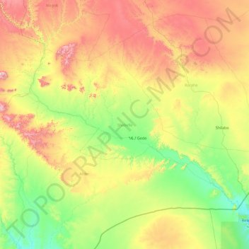
Name: Shabelle topographic map, elevation, terrain.
Location: Shabelle, Somali Region, Ethiopia (4.94582 42.00011 7.32833 45.57393)
Average elevation: 569 m
Minimum elevation: 185 m
Maximum elevation: 1,695 m
Make a donation
Gear up for your next adventure:
As an Amazon Associate, this site earns from qualifying purchases at no extra cost to you.
Other topographic maps
Click on a map to view its topography, its elevation and its terrain.
Make a donation
Gear up for your next adventure:
As an Amazon Associate, this site earns from qualifying purchases at no extra cost to you.
Make a donation
Gear up for your next adventure:
As an Amazon Associate, this site earns from qualifying purchases at no extra cost to you.