
Glanmire topographic map
Click on the map to display elevation.
About this map
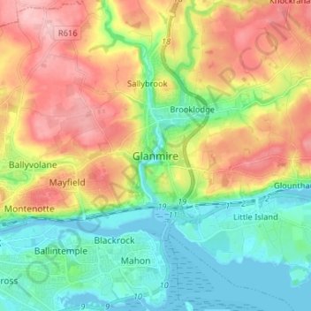
Name: Glanmire topographic map, elevation, terrain.
Location: Glanmire, County Cork, Munster, T45 X924, Ireland (51.87923 -8.43598 51.95923 -8.35598)
Average elevation: 58 m
Minimum elevation: -3 m
Maximum elevation: 143 m
Other topographic maps
Click on a map to view its topography, its elevation and its terrain.
Watergrasshill
According to A Topographical Dictionary of Ireland, published by Samuel Lewis in 1837, Watergrasshill then had a population of 533 people.
Average elevation: 164 m