
Isingiro topographic map
Interactive map
Click on the map to display elevation.
About this map
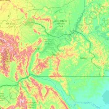
Name: Isingiro topographic map, elevation, terrain.
Location: Isingiro, Western Region, Uganda (-1.07623 30.47321 -0.60142 31.27016)
Average elevation: 1,358 m
Minimum elevation: 1,150 m
Maximum elevation: 1,902 m
Other topographic maps
Click on a map to view its topography, its elevation and its terrain.
Nyakisharara
Nyakisharara, Isingiro, Western Region, Uganda
Average elevation: 1,517 m
Lake Mburo-Nakivali Wetland
Lake Mburo-Nakivali Wetland, Isingiro, Western Region, Uganda
Average elevation: 1,355 m