
Alcombe topographic map
Interactive map
Click on the map to display elevation.
About this map
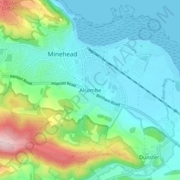
Name: Alcombe topographic map, elevation, terrain.
Average elevation: 68 m
Minimum elevation: 0 m
Maximum elevation: 287 m
Somerset trails, hiking, mountain biking, running and outdoor activities
Other topographic maps
Click on a map to view its topography, its elevation and its terrain.
Bishops Lydeard
United Kingdom > England > Somerset > Somerset West and Taunton > Bishops Lydeard
Average elevation: 60 m
Kingston St. Mary
United Kingdom > England > Somerset > Somerset West and Taunton > Kingston St. Mary
Average elevation: 92 m
Brompton Ralph
United Kingdom > England > Somerset > Somerset West and Taunton
Average elevation: 224 m