Geolocate

Ash topographic map

Click on the map to display elevation.

About this map

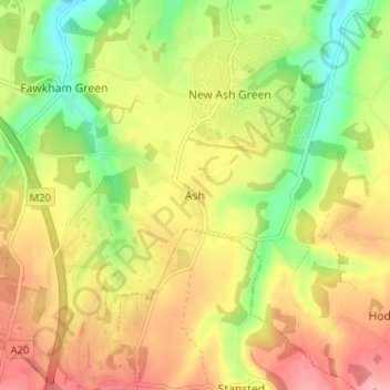
Name: Ash topographic map, elevation, terrain.

Location: Ash, Sevenoaks, Kent, England, TN15 7HB, United Kingdom (51.33532 0.27780 51.37532 0.31780)

Average elevation: 139 m

Minimum elevation: 80 m

Maximum elevation: 193 m

Kent trails, hiking, mountain biking, running and outdoor activities

Other topographic maps

Click on a map to view its topography, its elevation and its terrain.

Westerham

United Kingdom > England > Kent > Sevenoaks > Hosey Hill

Average elevation: 134 m

Darent

United Kingdom > England > Kent > Sevenoaks

Average elevation: 92 m

Eynsford

United Kingdom > England > Kent > Sevenoaks > Eynsford

Average elevation: 104 m

Kemsing

United Kingdom > England > Kent > Sevenoaks

Average elevation: 139 m

Sevenoaks

United Kingdom > England > Kent > Sevenoaks

Average elevation: 127 m

Penshurst

United Kingdom > England > Kent > Sevenoaks

Average elevation: 66 m

Chiddingstone

United Kingdom > England > Kent > Sevenoaks

Average elevation: 64 m

Riverhead

United Kingdom > England > Kent > Sevenoaks

Average elevation: 131 m

Shoreham

United Kingdom > England > Kent > Sevenoaks

Average elevation: 123 m

Hartley

United Kingdom > England > Kent > Sevenoaks

Average elevation: 99 m

Fawkham

United Kingdom > England > Kent > Sevenoaks

Average elevation: 108 m

Cowden

United Kingdom > England > Kent > Sevenoaks

Average elevation: 90 m

Crockenhill

United Kingdom > England > Kent > Sevenoaks

Average elevation: 96 m

Seal

United Kingdom > England > Kent > Sevenoaks

Average elevation: 117 m

Hextable

United Kingdom > England > Kent > Sevenoaks > Hextable

Average elevation: 61 m

Shoreham

United Kingdom > England > Kent > Sevenoaks

Average elevation: 123 m

Riverhead

United Kingdom > England > Kent > Sevenoaks

Average elevation: 131 m

Hever

United Kingdom > England > Kent > Sevenoaks

Average elevation: 65 m

Eynsford

United Kingdom > England > Kent > Sevenoaks > Eynsford

Average elevation: 104 m

Seal

United Kingdom > England > Kent > Sevenoaks

Average elevation: 117 m

Sevenoaks

United Kingdom > England > Kent > Sevenoaks

Average elevation: 127 m

Penshurst

United Kingdom > England > Kent > Sevenoaks

Average elevation: 66 m

Gear up for your next adventure:

🚲Bikepacking Frame Bags - Storage for tools and navigation gear on long off-road rides
🛌Insulated Sleeping Mats - Crucial thermal protection when sleeping on cold, uneven ground
📷Outdoor Action Cameras - Cameras designed for hiking and adventure
🧴Tick Removal Tools - Small, essential health tool for UK woodland and moorland
🧥Packable Down Jackets - Lightweight warmth that compresses small in your bag

As an Amazon Associate, this site earns from qualifying purchases at no extra cost to you.