
Penshurst topographic map
Click on the map to display elevation.
About this map
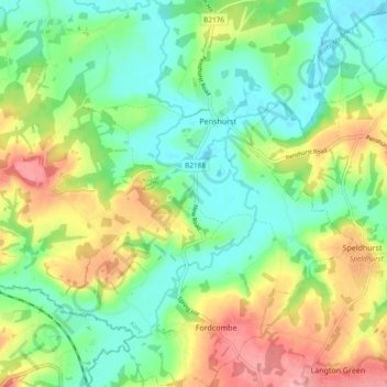
Name: Penshurst topographic map, elevation, terrain.
Location: Penshurst, Sevenoaks, Kent, England, United Kingdom (51.13179 0.15014 51.19077 0.21541)
Average elevation: 66 m
Minimum elevation: 24 m
Maximum elevation: 135 m
Kent trails, hiking, mountain biking, running and outdoor activities
Other topographic maps
Click on a map to view its topography, its elevation and its terrain.
Knatts Valley
United Kingdom > England > Kent > Sevenoaks > East Hill > Knockmill
Average elevation: 170 m