
Make a donation
Gear up for your next adventure:
As an Amazon Associate, this site earns from qualifying purchases at no extra cost to you.
Opuwo topographic map
Click on the map to display elevation.
Make a donation
Gear up for your next adventure:
As an Amazon Associate, this site earns from qualifying purchases at no extra cost to you.
About this map
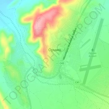
Name: Opuwo topographic map, elevation, terrain.
Location: Opuwo, Kunene Region, Namibia (-18.07239 13.82359 -18.04095 13.86161)
Average elevation: 1,155 m
Minimum elevation: 1,107 m
Maximum elevation: 1,242 m
Make a donation
Gear up for your next adventure:
As an Amazon Associate, this site earns from qualifying purchases at no extra cost to you.
Other topographic maps
Click on a map to view its topography, its elevation and its terrain.
Khorixas
Namibia > Kunene Region > Khorixas
The regional hospital and some other regional offices are located in Khorixas, though the capital of the Kunene Region is Opuwo. Khorixas has a landing strip nine kilometers east of town parallel to the C39 main road. The Runway Numbers are 09/27 and elevation is 3320 feet.
Average elevation: 974 m
Make a donation
Gear up for your next adventure:
As an Amazon Associate, this site earns from qualifying purchases at no extra cost to you.
Khorixas
Namibia > Kunene Region > Khorixas
The regional hospital and some other regional offices are still located in Khorixas, though the capital of Kunene Region is Opuwo. Khorixas has a landing strip nine kilometers east of town parallel to the main road C39. The Runway Numbers are 09/27 and elevation is 3320 feet.
Average elevation: 974 m
Make a donation
Gear up for your next adventure:
As an Amazon Associate, this site earns from qualifying purchases at no extra cost to you.